
Prominence 1,496 m (4,908 ft) Elevation 1,496 m | Mountain type Stratovolcano Last eruption 2009 | |
 | ||
Similar Kasatochi Island, Chikurachki, Alaid, Rasshua, Ketoy | ||
Sarychev Peak (Russian: вулкан Сарычева, Vulkan Sarycheva, variants: Japanese: 芙蓉山 Fuyō Mountain, Fuyō-san, Fuyō-yama, Fuyo-zan, Huyō San, Japanese: 松輪富士 Matsuwa-fuji), is a stratovolcano covering almost the entirety of Matua Island in the Kuril Islands, Russia. It is a young, highly symmetrical stratovolcanic cone.
Contents
Map of Sarychev Peak, Sakhalin Oblast, Russia, 694550
History
The peak was named after admiral Gavril Sarychev of the Imperial Russian Navy.
2009 eruption
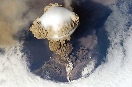
The volcano erupted June 11-21, 2009, sending out ash plumes. As the volcano is near some of the main air routes between East Asia and North America, there was some disruption to air traffic.
During an early stage of the eruption, on June 12, 2009, the International Space Station passed overhead and astronauts were able to photograph the event. A hole in the overhead clouds, possibly caused by the shock wave from the explosion, allowed a clear view of the plume and pyroclastic flow down the sides of the mountain. A cap-like pileus cloud is visible atop the rising column.
Sarychev Peak previously erupted in 1760, 1805, 1879, 1923, 1927, 1928, 1930, 1932, 1946, 1954, 1960, 1965, 1976, 1986 and 1989.