
 | ||
Similar Mount Rainier National, Mount Rainier, Cascade Range, Inter Glacier, Little Tahoma Peak | ||
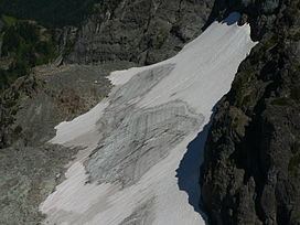
The Sarvant Glacier is a glacier located on the northern slopes of the Cowlitz Chimneys in Washington. Named for Henry M. Sarvant, who mapped Mount Rainier in 1894, the glacier starts at an elevation of about 7,000 feet (2,100 m) and descends northward down to 6,100 ft (1,900 m). There are several patches of permanent ice and snow that lie to the east and west of the glacier. These range in elevation from about 7,000 ft (2,100 m) to 5,700 ft (1,700 m). The patches of ice and snow to the west are labeled Sarvant Glaciers.
Map of Sarvant Glacier, Washington 98304, USA
References
Sarvant Glacier Wikipedia(Text) CC BY-SA