
Population 222 (2011) Civil parish Sarre Local time Wednesday 9:39 PM District Thanet UK parliament constituency North Thanet | OS grid reference TR255645 Sovereign state United Kingdom Dialling code 01843 | |
 | ||
Weather 7°C, Wind SE at 8 km/h, 88% Humidity | ||
Sarre is a village and civil parish in Thanet District in Kent, England. The village is a part of St. Nicholas-at-Wade ecclesiastical parish, after having lost the local church of St. Giles in Elizabethan times; the ecclesiastical parishes were subsequently combined. In its own right Sarre is an Ancient Parish. It has a population of 130, increasing to 222 at the 2011 Census.
Contents
Map of Sarre, UK
Sarre is located at the point where the old 'Island Road' from Margate to Canterbury crossed the Wantsum Channel initially by a ferry and from the late Middle Ages by a bridge. The route of this bridge is followed by a short section of the modern A28 and is still marked on some maps as Sarre Wall.
Mediaeval
The important late Roman or early Anglo-Saxon Sarre Brooch was found near the village; it is now on display in the British Museum (near the Sutton Hoo finds), along with many other important early medieaval artefacts from the same cemetery.
The coastal confederation of Cinque Ports during its mediæval period consisted of a confederation of 42 towns and villages in all. Which included Sarre, under the 'limb' of Sandwich, Kent.
World War II
In July 1940 the village was turned into a model strong point by the 1st Canadian Pioneer Battalion. Within three weeks the village bristled with defences including fifteen casemates and a variety of flame traps, flame fougasses and other anti-tank devices.
The Canadian commander Andrew McNaughton later recalled: "I turned a pioneer battalion loose to fortify Sarre in every possible way. They took ladies' boudoirs and turned them into machine-gun posts without showing anything from the outside; I'm sure they never got the concrete out. There was a big building inside the village that had a hoist for casks. The boys arranged a big barrel of petroleum, with phosphorus bombs inside, that was all poised ready to swing. When a tank came through the village and slowed to make the turn they would just pull a catch and the barrel would smack the tank fair and square and go off with a great gust of flame."
While McNaughton was inspecting the defences in August 1940, the village was attacked from the air and three bombs were dropped. A cottage was hit killing one adult and two or three children.
Today
The village has one public house, The Crown Inn – this being known locally as the 'Cherry Brandy House'. A special recipe of Cherry Brandy can be purchased from behind the bar. A second public house, the King's Head, recently closed and was sold privately.
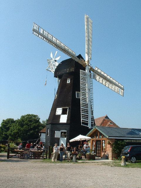
The village mill (Sarre Windmill) was previously open to the public as a working windmill. Recently, the mill has closed and is not open to the public except for the ground floor which is a holiday cottage for two. The mill shop is now also a holiday cottage. The surrounding buildings, including the Old Bakery and the Old Granary (which was originally thatched), have been sold privately and are now subdivided properties.
Nearest Stations: Birchington and Sturry from which regular buses operating on the Margate/Ramsgate to Canterbury route can be obtained.