
Isolation 62 kilometres (39 mi) Prominence 1,519 m Easiest route Hiking Listing Ultra-prominent peak | Elevation 2,089 m Parent range Scandinavian Mountains | |
 | ||
Similar Kaskasapakte, Kaskasatjåkka, Store Lenangstind, Storvätteshågna, Kebnekaise | ||
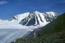
Sarektjåkkå is the second highest mountain in Sweden and the highest mountain in the Laponian area at 2.089 kilometers (1.298044 miles) AMSL. The mountain is located close to the eastern border of Sarek National Park, about 23 kilometres south-west of Suorva.
Contents
Map of Sarektj%C3%A5kk%C3%A5, 982 99 G%C3%A4llivare, Sweden
Climbing
Sarektjåkkå is not easily accessible by any nearby roads, so the approach normally takes a day or more of backcountry hiking.
Accessing the north summit, at 2.056 kilometers altitude, is a moderate but steep hike up. The actual summit (Stortoppen) is located about 600 metres southwest of the north summit via a ridge and is not as easy to reach, requiring exposed scrambling. An alternative route is to scale the summit from the south by merely steep hiking, but this requires crossing glaciers.