
Country Philippines Barangays Area 97.72 km² Local time Wednesday 11:19 PM | Founded 1980 Time zone PST (UTC+8) Province Davao Occidental | |
 | ||
Region Davao Region (Region XI) District Lone District of Davao Occidental Weather 27°C, Wind NE at 23 km/h, 87% Humidity Neighborhoods Tubay, Lipol, Sabang, Tumanao, Ibran, Katingan | ||
Sarangani is a 4th class municipality in the province of Davao Occidental, Philippines. According to the 2015 census, it has a population of 24,039 people.
Contents
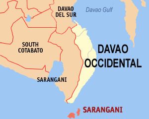
Map of Municipality of Sarangani, Davao del Sur, Philippines
The municipality consists of 2 major islands (the eponymous Sarangani Island and Balut Island) and 1 minor islet (Olanivan Island), collectively called as the Sarangani Islands, located just south of Mindanao island in the Celebes Sea.
Barangays
Sarangani is politically subdivided into 12 barangays.
Balut Island
Sarangani Island
Local government
Municipal officials 2013-2016:
References
Sarangani, Davao Occidental Wikipedia(Text) CC BY-SA