
- location City of Plattsburgh Length 130 km | - elevation 95 ft (29 m) | |
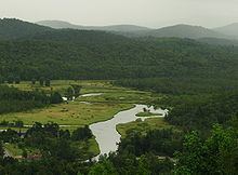 | ||
Saranac river plattsburgh ny september 2015
Saranac River is an 81-mile-long (130 km) river in the U.S. state of New York. In its upper reaches is a region of mostly flat water and lakes. The river has more than three dozen source lakes and ponds north of Upper Saranac Lake; the highest is Mountain Pond on Long Pond Mountain. In the last third of its length it drops two-thirds of its total drop, and is known for having navigable rapids, which make it a popular site for whitewater kayaking and canoeing.
Contents
- Saranac river plattsburgh ny september 2015
- Map of Saranac River New York USA
- Saranac river 2012
- References
Map of Saranac River, New York, USA
The Saranac River empties into Lake Champlain at the City of Plattsburgh in Clinton County, New York. The river flows in a northeasterly direction from the Adirondack Mountains.
The river encompasses Upper, Middle and Lower Saranac Lakes, as well as Oseetah Lake, Lake Flower, Franklin Falls Pond and Union Falls Pond, and flows through the village of Saranac Lake; there are locks between Middle and Lower Saranac Lakes and between Lower Saranac and Oseetah, although the drop is only a few feet. Thirty-three miles further northeast, the river flows through the Town of Saranac, before winding through Plattsburgh, reaching Lake Champlain after a further 23 miles.
The Saranac River has a fairly diverse fishery, including northern pike, largemouth bass, smallmouth bass, rock bass, pumpkinseed, fallfish, brown bullhead, brown trout, and landlocked atlantic salmon.
The river is also part of the 740-mile Northern Forest Canoe Trail, which begins in Old Forge, NY and ends in Fort Kent, ME.