
Country Thailand Time zone ICT (UTC+7) Geocode 1804 Population 44,553 (2008) | Seat Sapphaya Postal code 17150 Area 228.3 km² Province Chai Nat Province | |
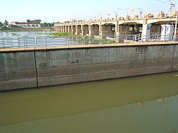 | ||
Sapphaya (Thai: สรรพยา) is the easternmost district (amphoe) of Chai Nat Province, central Thailand. The Chao Phraya Dam lies within the district.
Contents
Map of Sapphaya District, Chai Nat 17150, Thailand
Geography
Neighboring districts are (from the southwest clockwise) Sankhaburi, Mueang Chai Nat of Chai Nat Province, Takhli of Nakhon Sawan Province and In Buri of Sing Buri Province.
Administration
The district is divided into seven sub-districts (tambon), which are further subdivided into 55 villages (muban). There are six sub-district municipalities (thesaban tambon). Sapphaya covers parts of tambon Sapphaya, and Pho Nang Dam parts of tambon Pho Nang Dam Tok, while Taluk, Pho Nang Dam Ok, Bang Luang, and Hat Asa cover the whole same-named sub-district. There are another three tambon administrative organizations (TAO) covering the non-municipal areas of the sub-districts Supphaya, Khao Kaeo, and Pho Nang Dam Ok.