
Location South East Asia Highest elevation 360 m (1,180 ft) Elevation 360 m | Highest point Takuku Province Maluku | |
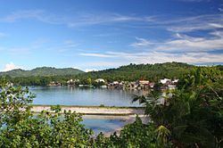 | ||
Saparua is an island east of Ambon Island in the Indonesian province of Maluku; the island of Haruku lies between Saparua and Ambon. The main port is in the south at Kota Saparua. The island of Maolana is located near its southwestern side and Nusa Laut off its southeastern tip.
Contents
Map of Saparua Island, Central Maluku Regency, Maluku, Indonesia
Saparua is administered as a single eponymous kecamatan of Maluku Tengah Regency, and has a population of 32,312 as of the 2010 census. The inhabitants of Saparua speak the Saparua language, as well as Indonesian and Ambonese Malay.
Saparua was the location of Indonesian national hero, Pattimura's rebellion against Dutch forces in 1817. It was also the birthplace of G.A. Siwabessy, a prominent politician who was Indonesia's Minister of Health during the 1960s and 1970s.