
Area 22.94 km² | ||
 | ||
Xxv premis sants montju c
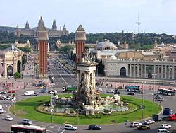
Sants-Montjuïc ([ˈsanz muɲʒuˈik]) is one of the ten districts Barcelona has been split in since 1984, numbered District 3. Comprising very different areas of the city, it covers the southern part of Barcelona, joining the two former districts II (made up by Montjuïc and Poble-Sec) and VII (Sants - Hostafrancs - La Bordeta), as well as the different areas comprised in the Zona Franca. As of the 2005 census it had a population of 177,636. It borders Les Corts, Eixample, Ciutat Vella, and the municipalities L'Hospitalet de Llobregat and El Prat de Llobregat.
Contents
- Xxv premis sants montju c
- Map of Sants MontjuC3AFc Barcelona Spain
- Ada colau sobre el desahucio de sants montju c 14 09 16
- Neighbourhoods
- References
Map of Sants - Montju%C3%AFc, Barcelona, Spain
It was one of the former municipalities added to Barcelona. The former municipality had the main nucleus in the neighbourhood of Sants but other current neighbourhoods of the district belonged to that municipality.
Ada colau sobre el desahucio de sants montju c 14 09 16
Neighbourhoods
(*) Not properly a neighbourhood, since they have no inhabitants, but they are part of the district not included in other neighbourhoods.