
State Amapá Elevation 5 m (15 ft) Area 1,578 km² Local time Wednesday 1:34 AM | Founded February 4, 1758 Time zone UTC-3 (UTC-3) Population 104,407 (2012) | |
 | ||
Clubs and Teams | ||
Santana is a municipality located in the southeast of the state of Amapá in Brazil. Its population is 98,600 and its area is 1,578 square kilometres (609 square miles), which makes it the smallest municipality of Amapá. Santana is a suburb of Macapá, the state capital, and the two cities make up the Metropolitan Area of Macapá. Its location is nearly on the equator. The planet's second longest river, the Amazon is to the south.
Contents
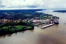
- Map of Santana Porto Santana Santana State of AmapC3A1 Brazil
- Neighbouring municipalities
- Districts
- Sports
- Twin towns Sister cities
- References
Map of Santana - Porto Santana, Santana - State of Amap%C3%A1, Brazil
Santana was historically a part of Macapá. In 1981 it was elevated to the category of a District of Macapá. It became a separate municipality in the state of Amapá on January 1, 1982.
Neighbouring municipalities
Districts
In 2001 Santana was officially divided into six districts.
Sports
Independente Esporte Clube and Santana Esporte Clube are the football clubs based in the city of Santana.
Twin towns — Sister cities
Santana, Amapá is twinned with: