
Time zone CET (UTC+0) Elevation 180 m Population 13,968 (2014) | Postal code 35459 Local time Wednesday 2:29 AM | |
 | ||
Weather 16°C, Wind NE at 26 km/h, 76% Humidity University Universidad Fernando Pessoa-Canarias Points of interest Caves of Valeron, El Brezal, Museo Néstor Álamo, AF Estrella Y Guia, Puente Silva | ||
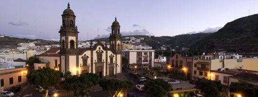
Santa María de Guía de Gran Canaria is a town and a municipality in Las Palmas province of the Canary Islands. It is located on the north side of Gran Canaria island. Its population is 13,811 (2013), and the area is 42.59 km2 (16.44 sq mi).
Contents
Map of Santa Mar%C3%ADa de Gu%C3%ADa de Gran Canaria, Las Palmas, Spain
The town Santa María de Guía is situated in a valley 2 km (1 mi) from the coast, 19 km (12 mi) west of Las Palmas. The municipality stretches from the coast into the mountainous interior of the island. The GC-2 motorway passes north of the town.
Heritage sites
The caves of Valerón, also called cenobio de Valerón, is a property of cultural interest in the "archaeological site" category. It is the largest pre-Hispanic collective granary. Its size is representative of Gran Canaria agriculture, unique among the Canaries islands in that it was traditionally dominated by plantations, with much of these being grains, rather than by stock-breeding.