
Time zone CET (UTC+1) Area 80.9 km² Local time Wednesday 12:36 AM | Elevation 984 m Population 1,111 (2014) | |
 | ||
Municipality Santa Eulalia del Campo Weather 7°C, Wind W at 3 km/h, 88% Humidity | ||
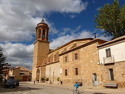
Santa Eulalia del Campo is a municipality located in the province of Teruel, Aragon, Spain. According to the 2005 census (INE), the municipality has a population of 1,171 inhabitants.
Contents
Map of Santa Eulalia del Campo, Teruel, Spain
This town is located near Sierra Palomera, a mountain range of the Sistema Ibérico.
Tourism
The surroundings of the Chapel of the Mill; Sierra Palomera with a view of the former premises of the Sugar Factory; Jiloca; the Media Caseta Mount or Mount Cirogrillos; Railway Station Via Minero Peirón of the Virgen del Pilar - on the road to the Tremedal Orihuela - are some of the tourist attractions.
References
Santa Eulalia del Campo Wikipedia(Text) CC BY-SA