
Age of rock 10,000 - 20,000 yrs Easiest route Hike | Last eruption Unknown | |
 | ||
Elevation 4843+ ft (1476+ m) NAVD 88 Similar Vulcan's Throne, Pinacate Peaks, Uinkaret volcanic field, Snow Canyon State Park | ||
Hiking the santa clara volcano
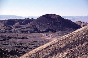
Santa Clara Volcano is a volcanic field and lava flow in the Diamond Valley in Washington County, Utah, United States. The most prominent features are two cinder cones that rise above Snow Canyon State Park. The southern cinder cone and most of the north cinder cone are within the boundaries of Snow Canyon State Park. The city of St. George, Utah is located in the volcanic field. The date of the last eruption is unknown.
Contents
- Hiking the santa clara volcano
- Map of Santa Clara Volcano Utah 84783 USA
- Boiling mudpools opposite santa clara volcano nicaragua avi
- References
Map of Santa Clara Volcano, Utah 84783, USA
Boiling mudpools opposite santa clara volcano nicaragua avi
References
Santa Clara Volcano Wikipedia(Text) CC BY-SA