
 | ||
Island group Channel Islands of California Similar Anacapa Island, Santa Rosa Island, San Miguel Island, Santa Cruz Island, SS Winfield Scott | ||
Santa barbara island kayaking camping snorkeling hiking and sea lions
Santa Barbara Island is a small island of the Channel Islands archipelago in Southern California. It is protected within Channel Islands National Park, and its marine ecosystem is part of the Channel Islands National Marine Sanctuary.
Contents
- Santa barbara island kayaking camping snorkeling hiking and sea lions
- Map of Santa Barbara Island California USA
- GeographyEdit
- GeologyEdit
- HistoryEdit
- Natural HistoryEdit
- References
Map of Santa Barbara Island, California, USA
GeographyEdit
The island is located about 38 miles (61 km) from the Palos Verdes Peninsula coast of Los Angeles County, Southern California, (near Ventura County and west of Greater Los Angeles.).
With a total area of about 1 square mile (640 acres or 260 hectares) it is the smallest of the eight Channel Islands. It is the southern-most island in the Channel Islands National Park. The highest peak on the island is Signal Hill, at 634 feet (193 m).
Although closer to mainland Ventura County and Los Angeles County, the island is part of Santa Barbara County (United States Census Bureau Block 3012, Block Group 3, Census Tract 29.10). It is the only one of the four southern Channel Islands included in the Channel Islands National Park, which also encompasses all four northern islands. According to the 2000 census the island is uninhabited and has a total land area of 1.0136 square miles (2.625 km2).
Like most of the Channel Islands, it can be seen from the mainland on exceptionally clear days (usually in winter).
GeologyEdit
While the island is not a volcano it is composed primarily of Miocene volcanic rocks (basalt) interbedded with marine sediments.
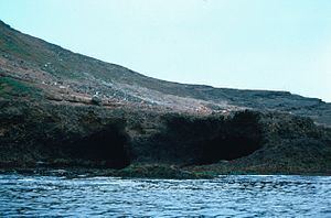
The steep wave-cut cliffs of its shoreline indicate that this is one of the younger Channel Islands. It exhibits at least six marine terraces; evidence of repeated tectonic uplift and subsidence (so called porpoising). Arch Point, on the north-east shore of the island is a 130 ft (40 m) arch caused by wave erosion of fault weakened rock.
Offshore, there are two named rocks: Sutil Island off the southwest end (12 acres (49,000 m2)) and Shag Rock off the northerly shore (1-acre (4,000 m2)) .
HistoryEdit
Native American peoples, probably the Chumash and Tongva, occupied Santa Barbara Island periodically for millennia. Archaeological sites dating to as much as 4,000 years ago have been documented on the island, which may have served as a stopover or refuge point for voyagers between the mainland and the other Channel Islands.
The first European visitor to the Channel Islands was Portuguese explorer João Rodrigues Cabrilho in 1542. He made no specific mention of this island.
Sixty years later, the island was named by Spanish explorer Sebastián Vizcaíno, who visited the island on December 4, 1602, the feast day dedicated to Saint Barbara.
In 1852, Charles Melville Scammon, in the brig Mary Helen, hunted northern elephant seals and sea lions on Santa Barbara Island. In December 1934, the steam-schooner California spent a week anchored off the island, processing blue, fin, and sperm whales caught by her two steam-driven whale catchers Hawk and Port Saunders.
Natural HistoryEdit
Santa Barbara Island is home to a large sea lion rookery and seabird nesting colonies. It is also home to the largest breeding colony for Scripps's murrelet, a threatened seabird species. Scripps's murrelet is listed as vulnerable because so much of its breeding takes place on such a small and isolated island.
Santa Barbara Island live-forever (Dudleya traskiae) is a succulent plant endemic to the island. A variety of St. Catherine's lace buckwheat (Eriogonum giganteum), Eriogonum giganteum var. compactum or Santa Barbara Island buckwheat, is endemic to and particularly rare on Santa Barbara Island.