
- location Rua do Outeiro Elevation 247 m Urban area 44 km² | - location Atlantic Ocean Area 8.73 km² Municipality Ponta Delgada | |
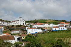 | ||
Santa Bárbara is a civil parish in the municipality of Ponta Delgada on the Portuguese island of São Miguel in the Azores. The population in 2011 was 855, in an area of 8.72 km². Santa Barbara is a relatively young administrative entity, established in 1986, being de-annexed from the neighboring parish of Santo António.
Contents
Map of Santa B%C3%A1rbara, Portugal
Geography
Santa Bárbara is sandwiched between Santo António (along the east and south), Remédios in the northwest, Sete Cidades to the southwest, and the Atlantic Ocean to the north. It is located in the northwestern part of the island of São Miguel. Apart from its church (to the invocation of Santa Bárbara), along with a few small commercial businesses, there is a restaurant and a local soccer field.
References
Santa Bárbara (Ponta Delgada) Wikipedia(Text) CC BY-SA