
Elevation 875 m (2,871 ft) Area 54 km² Postal code 83054 Dialling code 0827 | Frazioni See list Demonym(s) Santangiolesi Local time Tuesday 9:54 PM | |
 | ||
Weather 10°C, Wind S at 5 km/h, 71% Humidity | ||
Sant angelo dei lombardi avellino irpinia italy viaggio nei paesi d irpinia countries of irpinia
Sant'Angelo dei Lombardi is a town and comune in the province of Avellino in the Campania region of southern Italy.
Contents
- Sant angelo dei lombardi avellino irpinia italy viaggio nei paesi d irpinia countries of irpinia
- Map of 83054 SantAngelo dei Lombardi Province of Avellino Italy
- Sant angelo dei lombardi alle ore 19 30 non era ancora il 23 novembre 1980
- Geography
- History
- Earthquake and reconstruction
- References
Map of 83054 Sant'Angelo dei Lombardi Province of Avellino, Italy
Sant angelo dei lombardi alle ore 19 30 non era ancora il 23 novembre 1980
Geography
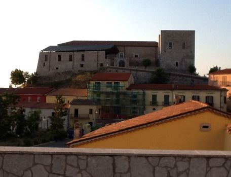
Sitting on a hilltop near the Fredano river, the town is home to a cathedral and a Lombard Castle. It is bordered by Guardia Lombardi, Lioni, Morra De Sanctis, Nusco, Rocca San Felice, Torella dei Lombardi and Villamaina.
Nearby is the Benedictine Abbey of San Guglielmo al Goleto.
History
The name "Sant'Angelo" derives from the town's patron saint Michael the Archangel. Lombardi is derived from the migrant workers of Lombardy who settled there around 1000 AD. The cathedral was originally built in the 11th century and was rebuilt in the 16th century. Also near the Piazza of Andrea is the castle of the Lombards, built around the first half of the 10th century. Initially it was a jail/prison/fort, and was later modified to serve as a castle. There is a small pathway that was constructed under the castle and from there it leads to the main town square where there lied an underground prison.
Earthquake and reconstruction
The town was virtually destroyed by the magnitude 6.9 Irpina earthquake of 23 November 1980. The town has been almost completely reconstructed but the town has yet to "come back to life."