
Population 6 Local time Tuesday 3:42 PM | OS grid reference NC427659 Sovereign state United Kingdom Postcode district IV27 4 Dialling code 01971 | |
 | ||
Weather 4°C, Wind SW at 16 km/h, 87% Humidity | ||
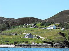
Sangobeg (Scottish Gaelic: Saingea Beag) is a remote coastal crofting township which overlooks Sangobeg Sands in Sutherland, Scottish Highlands in the Scottish council area of Highland. A legacy of the clearances, this small township sits near the township of Leirinmore on the edge of Durness around 1 mile (1.6 km) northwest along the A838 road.
Map of Sangobeg, Lairg, UK
References
Sangobeg Wikipedia(Text) CC BY-SA