
Disbanded 2007-07-01 Vehicle registration SGH Founded 1 October 1816 | Time zone CET (UTC+1) Area 689.7 km² Population 66,134 (2002) Date dissolved July 1, 2007 | |
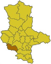 | ||
Sangerhausen was a district (Kreis) in the south of Saxony-Anhalt, Germany. Neighboring districts were (from north clockwise) Quedlinburg, Mansfelder Land, Merseburg-Querfurt, and the districts Kyffhäuserkreis and Nordhausen in Thuringia. Sangerhausen was merged on July 1, 2007 with Mansfelder Land into the new district Mansfeld-Südharz as part of a reform.
Contents
History
The district was created on October 1, 1816, after Sachsen-Weißenfels became part of Prussia in 1815. In 1945 the Amt Allstedt was added to the district, in 1952 some municipalities were removed from the district, which decreased the area from 773 to 689 km². In the communal reform of 1994 the district remained unchanged.
Geography
The highest elevation of the district is the Großer Auerberg near Stolberg with 579 m above sea level, the lowest elevation with 119.8 m is near Curtsgehofenmühle southwest of Allstedt.