
Country United States Time zone Eastern (EST) (UTC-5) Population 20,798 (2010) | State Maine Settled 1739 Elevation 80 m Local time Tuesday 9:59 AM | |
 | ||
Weather 4°C, Wind N at 3 km/h, 49% Humidity Colleges and Universities Seacoast Career Schools, Nasson College, Seacoast Career Schools-Sanford Campus | ||
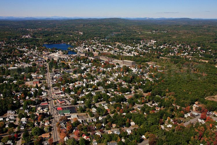
Sanford is a city in York County, Maine, United States. The population was 20,798 in the 2010 census, making it the seventh largest municipality in the state. Situated on the Mousam River, Sanford includes the village of Springvale. The city features many lakes in wooded areas which attract campers.
Contents
- Map of Sanford ME USA
- History
- Geography
- Demographics
- 2010 census
- 2000 census
- Fire Department
- Sites of interest
- Notable people
- References
Map of Sanford, ME, USA
Sanford is part of the Portland–South Portland–Biddeford, Maine metropolitan statistical area.
On November 6, 2012, Sanford voters approved a new charter to re-incorporate Sanford as a city and replace the town meeting format with a city council/mayor/strong manager form of government, along with other changes. The new charter took effect on January 1, 2013. Sanford's new charter provides that the first mayor would be appointed from the ranks of Sanford's seven city councilors and serve interim for one-year period. On January 8, 2013, Maura A. Herlihy was appointed as Sanford's first mayor.
In 2014, an elected-at-large mayor would take office and serve a three-year initial first term. On November 5, 2013, Thomas Cote was elected as mayor.
Beginning in 2016, the mayoral position will be elected at-large every two years during legislative election cycles.
History
Sanford is in the western portion of a tract of land purchased in 1661 from Abenaki Chief Fluellin by Major William Phillips, an owner of mills in Saco. First called Phillipstown, it was willed in 1696 by Mrs. Phillips to her former husband's son, Peleg Sanford. Settlement was delayed, however, by hostilities during the French and Indian Wars. In 1724, Norridgewock, an enemy stronghold on the Kennebec River, was destroyed by a Massachusetts militia. Subsequently, the region became less dangerous, and Sanford was first settled in 1739. Incorporated a town in 1768, it was named after Peleg Sanford. Until 1794, Alfred was the town's North Parish.
The Mousam River provided water power for industry. In 1745, Capt. Market Morrison built a sawmill above Springvale. Following the Civil War, Sanford developed into a textile manufacturing center, connected to markets by the Portland and Rochester Railroad. Factories were built at both Springvale and Sanford villages. Products included cotton and woolen goods, carpets, shoes and lumber.
In 1867, British-born Thomas Goodall established the Goodall Mills at Sanford, after selling another mill in 1865 at Troy, New Hampshire which made woolen blankets contoured to fit horses. His factory beside the Mousam River first manufactured carriage robes and blankets. It would expand to make mohair plush for upholstering railroad seats, carpets, draperies, auto fabrics, military uniform fabric and Palm Beach fabric for summer suits.
The company's textiles were known for brilliant and fast colors, and found buyers worldwide. From 1880 to 1910, the mill town's population swelled from 2,700 to over 9,000, some living in houses built by the company and sold to workers at cost. In 1914, the Goodall family built Goodall Park, a 784-seat roofed stadium, now a treasured historic site. They also helped build the library, town hall, hospital, airport and golf club. A bronze statue was erected by the citizens of Sanford in 1917 to the memory of Thomas Goodall. His effigy has a place of honor in Central Park. George and Henrietta Goodall's daughter, Marion C. Goodall Marland, and her husband William Marland, continued the Goodall family philanthropy. A dormitory at Nasson College bears the Marland's name.
In 1954, Burlington Mills, then the nation's largest textile firm, bought Sanford Mills. After moving the looms to its Southern plants, Burlington closed Sanford Mills—leaving 3,600 unemployed and 2,000,000 square feet (190,000 m2) of empty mills. Local business owners began traveling the northeast, enticing new employers to move to the area. Life Magazine called Sanford "the town that refused to die." It now has diversified industries, including the manufacture of aircraft parts. When the federal government offered money in the 1960s for urban renewal to rehabilitate aging or blighted districts, more than thirty Sanford structures were razed. In Springvale, three of four corners were leveled. Nevertheless, much fine architecture from the town's prosperous mill era survived.
Sanford was the home of Belle Ashton Leavitt, the third woman attorney admitted to the Maine Bar Association. Leavitt was admitted to the Bar in 1900. Leavitt operated in partnership with attorney Fred J. Allen, her brother-in-law (Allen was married to Belle's sister Ida Leavitt), and member of the Maine Legislature.
The town gained national notoriety in 1984, when 12-year-old Gycelle Cote was strangled by Scott Waterhouse, then 18. Rumors of Satanism surrounded the case, and some of Waterhouse's personal belongings were deemed to be occult in nature. These included a copy of The Satanic Bible and a notebook carrying Satanic drawings and poetry. The furor culminated in several tabloid stories and at least one headline referring to the town as "Terrortown!".
The town gained national notoriety again on November 9, 2009, when the Amber Alert system was used for the first time when 2 year old Hailey Traynham was abducted by her father.
In 2003, a proposal to build a $650 million casino in South Sanford was rejected by Maine voters. The 362-acre (1.46 km2) development, ostensibly owned by the Penobscot and Passamaquoddy nations, would have encompassed 4,000 slot machines, 180 gaming tables, a hotel, a 60,000-square-foot (5,600 m2) convention center and an 18-hole golf course. Proponents argued that it would add 4,700 permanent jobs and 25% of revenue would be directed to the state. Detractors predicted higher crime, traffic and an erosion of Maine's quality of life.
Geography
Sanford is located at 43°26′23″N 70°46′23″W (43.439925, -70.773304). According to the United States Census Bureau, the city has a total area of 48.75 square miles (126.26 km2), of which, 47.78 square miles (123.75 km2) of it is land and 0.97 square miles (2.51 km2) is water. Located near foothills, Sanford is drained by the Mousam River. Mt. Hope, elevation 680 feet (207 m) above sea level, is the city's highest point. The lowest elevation, which is approximately 140 feet (42.7 m) above sea level, is on the Mousam River at Old Falls Pond as flows into Kennebunk.
Sanford borders the towns of Shapleigh, Acton, Alfred, Kennebunk, Wells, North Berwick, and Lebanon.
Demographics
See also Sanford (CDP), Maine, South Sanford, Maine, and Springvale, Maine for village demographics.2010 census
As of the census of 2010, there were 20,798 people, 8,500 households, and 5,417 families residing in the city. The population density was 435.3 inhabitants per square mile (168.1/km2). There were 9,452 housing units at an average density of 197.8 per square mile (76.4/km2). The racial makeup of the city was 94.7% White, 0.6% African American, 0.4% Native American, 2.0% Asian, 0.3% from other races, and 2.0% from two or more races. Hispanic or Latino of any race were 1.6% of the population.
There were 8,500 households of which 30.6% had children under the age of 18 living with them, 44.7% were married couples living together, 13.1% had a female householder with no husband present, 5.9% had a male householder with no wife present, and 36.3% were non-families. 28.9% of all households were made up of individuals and 11.2% had someone living alone who was 65 years of age or older. The average household size was 2.41 and the average family size was 2.91.
The median age in the city was 40.5 years. 22.6% of residents were under the age of 18; 8.2% were between the ages of 18 and 24; 25% were from 25 to 44; 29% were from 45 to 64; and 15.1% were 65 years of age or older. The gender makeup of the city was 47.9% male and 52.1% female.
2000 census
As of the census of 2000, there were 20,806 people, 8,270 households, and 5,449 families residing in the CDP. The population density was 435.3 people per square mile (168.1/km²). There were 8,807 housing units at an average density of 184.3 per square mile (71.1/km²). The racial makeup of the CDP was 95.68% White, 0.44% Black or African American, 0.31% Native American, 2.07% Asian, 0.02% Pacific Islander, 0.27% from other races, and 1.21% from two or more races. Hispanic or Latino of any race were 0.96% of the population.
There were 8,270 households out of which 33.7% had children under the age of 18 living with them, 48.5% were married couples living together, 12.7% had a female householder with no husband present, and 34.1% were non-families. 27.6% of all households were made up of individuals and 11.7% had someone living alone who was 65 years of age or older. The average household size was 2.48 and the average family size was 3.01.
In the CDP the population was spread out with 26.7% under the age of 18, 8.1% from 18 to 24, 29.0% from 25 to 44, 21.8% from 45 to 64, and 14.4% who were 65 years of age or older. The median age was 37 years. For every 100 females there were 93.5 males. For every 100 females age 18 and over, there were 90.0 males.
The median income for a household in the CDP was $34,668, and the median income for a family was $43,021. Males had a median income of $33,115 versus $24,264 for females. The per capita income for the CDP was $16,951. About 11.1% of families and 12.8% of the population were below the poverty line, including 17.0% of those under age 18 and 11.2% of those age 65 or over.
Voter registration
Fire Department
Sanford citizens are protected by Firefighter/EMT's working out of three fire stations located in Springvale, South Sanford, and Downtown Sanford. 3 Engines, 1 Ladder, and 1 Rescue are staffed 24 hours a day; 365 days a year. Authorized strength is 45 full-time fire personnel. SFD also provides Emergency Medical Services. All firefighters are required to have a Maine EMS license ranging from EMT-Basic to Paramedic. In 2007 SFD responded to 1,150 Fire Runs & 2,515 Medical Runs for a total of 3,665 emergencies.