
 | ||
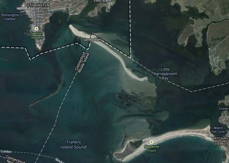
Sandy Point Island (more commonly referred to as Sandy Point) is a 35-acre island in Little Narragansett Bay. Once an extension of Napatree Point, Sandy Point is now its own entity. The 1938 Hurricane separated the peninsula, leaving Sandy Point a mile-long island and Napatree Point a shorter peninsula, still attached to the mainland.
Contents
- Map of Sandy Point United States
- GeographyEdit
- HistoryEdit
- Sandy Point today and conservation statusEdit
- Access to the islandEdit
- References
Map of Sandy Point, United States
GeographyEdit
The small island was made from the same longshore drift that created Napatree Point. The two pieces of land were one until the 1938 Hurricane tore several channels in the peninsula. The result was the separation of Napatree at the elbow, making Sandy Point an island. The land is low-lying and nearly all sand, aside from a few trees.
The 35-acre island is one mile long, and is about one half mile north of Napatree Point. Although the connection between the two has been broken, the waves break at the point where the peninsula once was. The underwater remains of the peninsula makes the area dangerous for many boaters.
HistoryEdit
Sandy Point was once the farthest extension of Napatree Point, a small peninsula off of Watch Hill, Rhode Island. It was covered in trees for many years. Once the region was struck with the Great September Gale of 1815, the trees were all destroyed. After this event, it took on its current form, a coastal beach.
It was attached to Napatree Point until the 1938 Hurricane made landfall on the Northeastern United States. When the hurricane struck the coast, it cut several channels into the peninsula. One of those channels broke Sandy Point away from Napatree, and to this day it remains an island, detached from the mainland.
In 1940, Sandy Point was deeded to Alfred Gildersleeve of Stonington, Connecticut. The Guildersleeve family gave Sandy Point to the Avalonia Land Conservancy in 1982 to be protected and used as a nature preserve.
Sandy Point today and conservation statusEdit
Sandy Point is now divided between two states. Of the 35-acre island, 30 of those acres belong to the state of Rhode Island. The remaining five acres, the northernmost five, are a part of the Town of Stonington, New London County, in the state of Connecticut. Sandy Point is recognized as a village of the Town of Westerly, in Washington County, Rhode Island.
After being given to the Avalonia Land Conservancy in 1982, it was used as a nature preserve. The island mainly serves as a breeding ground for several species of shoreline birds, including the least tern, the roseate tern, the piping plover, the American oystercatcher, and the herring gull, among others. It is also used for recreational purposes. The island is a popular beach for people because of its seclusion. It is also good for parents of young children because the water doesn't get much deeper than knee-deep along the shore. Today, the island is in the possession of the Land Conservancy, but is run in partnership with the U.S. Fish & Wildlife Service. Up until 2011, it was managed by the Stewart B. McKinney National Wildlife Refuge. However, it has since been added to the Rhode Island National Wildlife Refuge Complex, which has taken the Stewart B. McKinney Refuge's place.
There have been a few minor disputes over whether the island should be used as a bird sanctuary or as an area for public access. On February 3, 2010, the decision on management of the island was announced at a meeting in the Stonington Community Center. The Avalonia Land Conservancy signed a five-year management contract with the U.S. Fish & Wildlife Service, and the two reached an agreement. As of summer 2010, the northern and southern tips of the island, along with the middle region of the island, have been closed off and are to be used as nesting areas for the various birds that migrate to the island. The remainder of the island, a little over half, is still open to the public (with the purchase of a permit). The island has recently added information kiosks, managed by a few people from the Fish & Wildlife Service. The state boundaries have been marked, and fences have been put up to block off bird nesting areas.
Access to the islandEdit
It is somewhat difficult to access Sandy Point because there is no dock on the island. The island is most easily reached by boats with a shallow draft. It is also possible to reach the island by larger boats if one drops anchor offshore and rows or swims in to the beach.
Anyone who wishes to visit the island during the summer must obtain a permit from the Stonington Community Center. Permits can be purchased for individual days or for the whole season.