
Primary outflows Opo river Surface elevation 88 m Length 4.8 km Shore length 11.9 km | Primary inflows Area 4.3 km² Width 1.5 km | |
 | ||
Max. length 4.8 kilometres (3.0 mi) Max. width 1.5 kilometres (0.93 mi) | ||
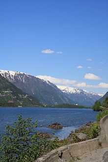
Sandvinvatnet is a lake in the municipality of Odda in Hordaland county, Norway. The 4.3-square-kilometre (1.7 sq mi) lake lies on the southern edge of the town of Odda. The Buerdalen valley and Buarbreen glacier lie to the east of the lake. The Norwegian National Road 13 runs along the east side of the lake. The lake water flows north into the short river Opo, before entering the Sørfjorden.
Map of Sandvinvatnet, 5750 Odda, Norway
References
Sandvinvatnet Wikipedia(Text) CC BY-SA