
 | ||
Similar Culver Down, Dinosaur Isle, Shanklin Beach, St Boniface Down, Bembridge Fort | ||
28 sandown bay holiday centre sandown united kingdom hd review
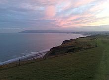
Sandown Bay is a broad bay which stretches for much of the length of the Isle of Wight's southeastern coast. It extends ten kilometres from Culver Down and Yaverland in the northeast to just south of Shanklin in the southwest, near the village of Luccombe. Near Luccombe, the bay is separated from The Undercliff by a large headland from which Lowtherville sits atop. The towns of Shanklin, Lake and Sandown are located on the bay's coast, while Luccombe and Lowtherville feature panoramic views across both Sandown Bay to the East and the Undercliff to the southwest.
Contents
- 28 sandown bay holiday centre sandown united kingdom hd review
- Map of Sandown Bay United Kingdom
- 28 sandown bay holiday centre sandown united kingdom review hd
- References
Map of Sandown Bay, United Kingdom
The seabed is a mixture of sand, shells and gravel. The beach is predominantly sand.
Large cargo ships can frequently be observed operating in Sandown Bay, often using the bay as a temporary anchorage before continuing east towards continental Europe.
The bay is best viewed from Culver Down to the north. The Isle of Wight Coastal Path follows the whole bayline either along the cliff top to the south of Sandown or the concrete seawall north of Sandown.
Sandown Bay is an excellent example of a concordant coastline, and has well-developed beaches stretching all the way from Shanklin to Culver Down due to Longshore drift. As a result of this, Sandown and Shanklin grew rapidly in the 1800s into bustling seaside resorts, as tourists from across both the Island and the country came to enjoy the seaside.