
Population (2008) 701 Area 15.53 km² | Canton Sancergues Time zone CET (UTC+1) Local time Tuesday 8:09 AM | |
 | ||
Weather 8°C, Wind SW at 11 km/h, 98% Humidity | ||
Sancergues is a commune in the Cher department in the Centre region of France.
Contents
Map of 18140 Sancergues, France
Geography
A farming area comprising a village and several hamlets situated about 20 miles (32 km) northeast of Bourges, at the junction of the N151 with the D72, D6 and the D44 roads. The commune is on the ancient pilgrimage route known as St. James' Way and lies on the left bank of the Vauvise, which forms most of the commune's eastern border.
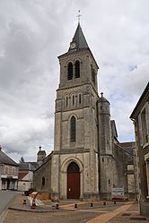
Sights
References
Sancergues Wikipedia(Text) CC BY-SA