 | ||
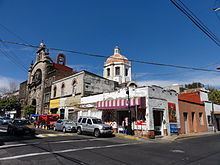
San Miguel Chapultepec is a colonia or neighborhood in Delegación Miguel Hidalgo in Mexico City.
Contents
- Map of San Miguel Chapultepec Mexico City CDMX Mexico
- Demographics
- Religious buildings
- Hospital
- Public transportation
- References
Map of San Miguel Chapultepec, Mexico City, CDMX, Mexico
Its borders are:
The colonia's streets carry the names of generals and governors of Mexico. The buildings mostly consist of houses, whether still used as residences or converted into offices. Being a central neighborhood where the Circuito Interior freeway, Ave. Constituyentes (a main through road to Santa Fe, Toluca and points west), and the Ejes viales 2 and 4 South, the area is saturated with traffic.
Demographics
INEGI reported 7 605 inhabitants in 2005.
Religious buildings
Hospital
The Mocel hospital of the Grupo Ángeles group is located here.
Public transportation
Metro stations on the neighborhood's border are Chapultepec, Juanacatlán on Line 1; Constituyentes de la Line 7 y Tacubaya de la 1, 7 y 9.
Metrobús Line 2 serves Eje 4 Sur until Tacubaya with stops at De La Salle, Parque Lira, Tacubaya and Antonio Maceo (corner of Jalisco).
In the neighborhood there are EcoBici bikeshare bikes.
