
Comarca Nalón Highest elevation 1,096 m (3,596 ft) Area 56.13 km² | Time zone CET (UTC+1) Population 17,460 (2014) Local time Tuesday 2:50 AM | |
 | ||
Weather 10°C, Wind S at 6 km/h, 83% Humidity | ||
Happy from san mart n del rey aurelio
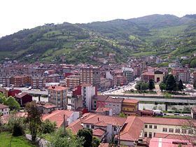
San Martín del Rey Aurelio (Asturian: Samartín del Rei Aurelio) is a municipality of the Autonomous Community of the Principality of Asturias in northern Spain.
Contents
- Happy from san mart n del rey aurelio
- Map of San MartC3ADn del Rey Aurelio Asturias Spain
- San mart n del rey aurelio miradas de asturias cap 60
- Parishes
- References
Map of San Mart%C3%ADn del Rey Aurelio, Asturias, Spain
There are three principal towns in the municipality: Sotrondio, El Entrego, and Blimea, and many villages, such as Santa Bárbara and La Hueria.
It is situated in the central part of Asturias, just below the Sierra de San Mamés, part of the Cantabrian Mountains. The Nalón River, the longest river in Asturias, crosses the municipality. The Redes Natural Park is located nearby.
Historically a mining location, nowadays it is in a re-industrial process with the emigration of many young people (about 30% of under 30). New computer based factories are attempting to establish themselves.
San mart n del rey aurelio miradas de asturias cap 60
References
San Martín del Rey Aurelio Wikipedia(Text) CC BY-SA