
Location SamarLeyte | ||
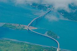 | ||
San Juanico Strait (Filipino: Kipot ng San Juanico) is a narrow strait in the Eastern Visayan region in the Philippines. It separates the islands of Samar and Leyte, and connects the Carigara Bay (Samar Sea) with the San Pedro Bay (Leyte Gulf). It is about 38 kilometres (24 mi) long, and at its narrowest point, the strait is only 2 kilometers (1.2 mi) wide.
Map of San Juanico Strait, Philippines
It is crossed by the San Juanico Bridge. The HVDC Leyte–Luzon powerline crosses San Juanico Strait as overhead line at 11°23′36″N 124°59′04″E, with a tower on an uninhabited island in the strait. The Port of Tacloban City, the main port of the Eastern Visayas, is on Cancabato Bay at the southern entrance of the strait.
References
San Juanico Strait Wikipedia(Text) CC BY-SA