
Time zone MST (UTC−7) Population 2,983 (2010) Area code 648 | Area 1,169 km² | |
 | ||
Municipality created 1825; 192 years ago (1825) | ||
San Francisco de Conchos is one of the 67 municipalities of Chihuahua, in northern Mexico. The municipal seat lies at San Francisco de Conchos. The municipality covers an area of 1,169.1 km².
Contents
- Map of San Francisco de Conchos Chihuahua Mexico
- History
- Coat of arms
- Geography
- Flora vegetation
- Fauna wild life
- Farming
- Tourism
- Demography
- Locations
- Politics
- Mayors
- Legislative representation
- Notable People
- Religion
- References
Map of San Francisco de Conchos, Chihuahua, Mexico
As of 2010, the municipality had a total population of 2,983, up from 2,669 as of 2005.
As of 2010, the town of San Francisco de Conchos had a population of 644. Other than the town of San Francisco de Conchos, the municipality had 93 localities, the largest of which (with 2010 population in parentheses) was: Boquilla de Babisas (La Boquilla de Conchos) (1,185).
History
Since the beginning of the eighteenth century, the Franciscans occupied the region and evangelized indigenous tribes of the Conchos, who could not submit.
In 1687 he underwent military regime Presidio; in 1820, according to the Constitution of Cadiz, he elected local council. He was part of the Party of Allende (1826); Deputy Chief of Jimenez (1837); and Canton Jimenez (1847).
The original name was the head San Francisco de Coyamus, founded in 1604 by the Franciscan Alonso de la Oliva on the banks of the Conchos River.
In 1645 the mission was destroyed by the Indians who killed the missionaries Thomas & Zigarán and Francisco Labado.
Sierra Lopez y Osorio, governor of Nueva Vizcaya, licensed sent repopulate in 1677, with the current name.
When it is created in 1867 the presidio the seat was changed from the mission to the people who called Guadalupe, where today the population rises.
Coat of arms
The official seal of the municipality was designed by Mr. Manuel Vazquez Carrasco
The coats of arms that are within the stylized field are:
Geography
The municipality of San Francisco de Conchos is in the southern state of Chihuahua in the region of the Conchos River, its boundaries are the north with the municipality of Saucillo, northeast in the municipality of La Cruz, east to the town of Camargo the south with the municipality of Allende and the west with the municipality of Valle de Zaragoza; It has a land area of 1,169.10 square kilometers.
The municipality is in the plateau region, so that its territory is mostly flat, interrupted by some low hills that cross the plains, the main of these mountains are the local names of La Boquilla, La Colina and Pajaritos.
The main current of the municipality is Conchos River, the largest in the state of Chihuahua, which crosses the city from west to east, in the exact boundary of San Francisco de Conchos with the municipality of Valle de Zaragoza curtain Dam is located La Boquilla dam, the largest dam of the state of Chihuahua, in the center of the municipality is another dam that forms Colina Lake which is a spa; whole municipality belongs to hydrologic Region Bravo-Conchos and two different basins, the western area Conchos River - Colina dam and the eastern sector Conchos River - El Granero dam.
Flora (vegetation)
It is predominantly a desert of scrub and grassland. Among the species that stand out are the creosote, gobernadora or hediondilla and hojasen or weed rubber, which is a characteristic species and is found more dispersed, but can cover large areas under certain conditions and soil moisture. Other common plants in the northern part of the territory include shrubs such as shack or rib cow, mariola or guayule, and the sweet mesquite. Similarly there are succulents, cacti and some small to medium, such as the cholla, palmitas or yuccas, agaves and such as lechuguilla, characteristic of this desert. Grassland plants are also common, like the black penknife and common toboso or cookie grass. Other common plants are the ocotillo, sotol, khella water or barrel cactus, and peyote.
Fauna (wild life)
Some typical animals of this village are desert rabbit, hare California, cactus mouse, the swift fox, the coffee or desert wren, Northern roadrunner, the Mojave rattlesnake, the Chirrionera snake, the huico New Mexico or whiptail lizard, the spotted toad, the tiger salamander, Rat timber, the pallid bat, the coyote, the Mexican gray wolf, hooded skunk, the Wildcat, mule deer and the puma concolor
Farming
It is the main economic activity in the region and mainly products such as jalapeño, alfalfa, beans, corn grain, grass, grain sorghum, red tomato, green tomato and wheat grain sown. Also it has an important nut production.
Tourism
Tourism is the second most important economic activity for the city and state is the second destination during summer vacation. To contain the largest body of water in the state La Boquilla Dam and below this a small dam called Colina Lake, these waters are used for water sports activities (like boat rides and jet skis, skiing and fishing) and not forgetting the famous spas Los Filtros for its spring waters.
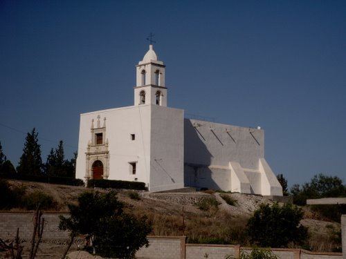
The church of San Francisco de Asis is located in the municipal head is the most important monument of the town since its construction dates from 1710 and is still standing, the remains of the Temple of Guadalupe (located in the municipal cemetery before military prison) and the aqueduct are other important buildings of the colonial era.
Demography
According to the Census of Population and House 2010 conducted by the National Institute of Statistics and Geography (INEGI), the population of the municipality of San Francisco de Conchos it is of 2,938 inhabitants, of whom 1,549 are men and 1,434 are women.
Locations
The municipality has a total of 46 locations. The main localities and their population are the following:
Politics
San Francisco de Conchos is one of 67 municipalities that make up the state of Chihuahua, the government of the municipality corresponds to City Hall, which is composed of the Mayor and the council made up of the rulers. The H. City Council is elected for a period of three years are not eligible for reappointment for immediate but not continuous period.
Mayors
The following table is to list the mayors and period:
Legislative representation
For the election of Deputies to Congress of Chihuahua and to General Congress, the municipality of San Francisco de Conchos is composed as follows:
Local:
Federal
Notable People
Religion
The population is predominantly Catholic, with a growing number of evangelical Christians (Protestants): Pentecostals, Baptists, Presbyterians and Methodists.
Also about 2 percent belong to other Christian groups (Jehovah's Witnesses, Mormons, Oneness Pentecostal)