
Elevation 667 m Local time Saturday 4:59 PM | Area 81.43 km² Population 461 (2014) | |
 | ||
Weather 14°C, Wind W at 14 km/h, 53% Humidity | ||
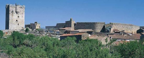
San Felices de los Gallegos is a village and large municipality in the province of Salamanca, western Spain, part of the autonomous community of Castile-Leon. It is located at 102 kilometres from the provincial capital city of Salamanca and has a population of 600 people. It is situated within the Arribes del Duero Natural Park.
Contents
- Map of 37270 San Felices de los Gallegos Salamanca Spain
- Segundo encierro de las fiestas del noveno en san felices de los gallegos
- History
- Geography
- References
Map of 37270 San Felices de los Gallegos, Salamanca, Spain
Segundo encierro de las fiestas del noveno en san felices de los gallegos
History
As a result of the Treaty of Alcañices in 1297 the village became part of the Kingdom of Portugal, with the name of São Felix de Galegos, along with other Spanish towns: Hermisende (Ermesende in Portuguese), Salvaterra de Miño (Salvaterra do Minho), Olivenza (Olivença; including the current municipality of Táliga). The Portuguese held San Felices de los Gallegos until 1327 and occupied it briefly c. 1370 and again c. 1476.
Geography
The municipality covers an area of 81.43 km².
It lies 667 metres above sea level.
The post code is 37270.