
Area 3,348 km² Capital Quesada, Costa Rica | Founded 26 September 1911 Population 178,460 (Jun 2013) | |
 | ||
Points of interest Arenal Volcano, La Fortuna Waterfall - Costa Rica, Chato Volcano, Mistico Arenal Hanging, Kalambu Hot springs Destinations La Fortuna - Costa Rica, Arenal Volcano National, Lake Arenal, Juan Castro Blanco N, Quesada - Costa Rica | ||
San Carlos is the 10th canton in the province of Alajuela in Costa Rica. The canton covers an area of 3,347.98 square kilometres (1,292.66 sq mi), making it the largest canton in the country. It has a population of 178,460 (estimate as of 2013). ranking it fifth.
Contents
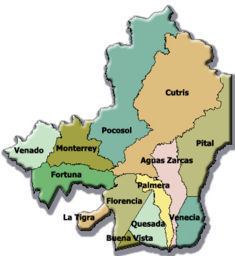
Map of Alajuela Province, San Carlos, Costa Rica
The capital city of the canton is Ciudad Quesada, which is also known as San Carlos.
Geography
The canton encompasses a major portion of the Llanura de San Carlos (San Carlos Plain), a wide expanse on the Caribbean side of the Cordillera Central (Central Mountain Range). San Carlos reaches north to the border of Nicaragua, east to the province of Heredia, west to the province of Guanacaste, and south into the heights of the Cordillera.
San Carlos is noted as the home of Arenal Volcano, one of the most active volcanoes in the world. The canton's principal economic activities include the production of oranges, yuca, pineapple, sugar cane, beef and dairy products. More than 50% of the total production of milk in Costa Rica comes from San Carlos.
There is a branch of the Costa Rica Institute of Technology in Ciudad Quesada.
Districts
The canton of San Carlos is subdivided into 13 districts (distritos):
- Quesada
- Florencia
- Buenavista
- Aguas Zarcas
- Venecia
- Pital
- La Fortuna
- La Tigra
- La Palmera
- Venado
- Cutris
- Monterrey
- Pocosol
History
The canton was established by a decree of September 26, 1911.