
- average 2,120 cu ft/s (60 m/s) Length 89 km | - elevation 607 ft (185 m) - elevation 449 ft (137 m) Basin area 6,522 km² | |
 | ||
- max 107,000 cu ft/s (3,030 m/s) | ||
The Salt River is a tributary of the Mississippi River in eastern Missouri in the United States. The river is approximately 55 miles (89 km) long and drains an area of 2,518 sq mi (6,520 km2) in parts of twelve Missouri counties.
Map of Salt River, Missouri, USA
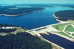
It rises at the confluence of the North, Middle, and South Forks in Monroe County. Since Clarence Cannon Dam construction was completed in 1983, the first 15 miles of the Salt River after the confluence of the North, Middle, and South Fork have been contained in Mark Twain Lake. Below the dam, the river winds generally east for 63 miles through a rural valley surrounded by low bluffs. Below New London, it receives Spencer and Peno Creeks from the right. The Salt joins the Mississippi River at Ted Shanks Wildlife Conservation Area (River Mile 284) just above the town of Louisiana in Pike County.
The river was called "Ohaha" by the Native Americans that once lived along its course. It was also known as "the river Jeffreon" in the 1804 Treaty of St. Louis. American author Mark Twain was born in the town of Florida on the Salt River in 1835.