
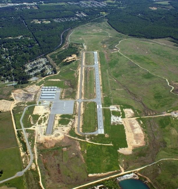
Airport type Public Elevation AMSL 390 ft / 119 m 5,001 1,524 Elevation 119 m | 2/20 5,001 1,524 Asphalt Phone +1 501-672-9809 | |
 | ||
Address 1100 Hill Farm Rd, Bryant, AR 72022, USA | ||
Saline County Regional Airport (ICAO: KSUZ, FAA LID: SUZ) is a county owned, publicuse airport located five nautical miles (6 mi, 9 km) east of the central business district of Benton, a city in Saline County, Arkansas, United States. The airport's address is 1100 Hill Farm Road in Bryant, Arkansas. It is included in the FAA's National Plan of Integrated Airport Systems for 2011–2015, which categorized it as a general aviation facility.
Contents
Although most U.S. airports use the same three-letter location identifier for the FAA and IATA, this facility is assigned SUZ by the FAA but has no designation from the IATA (which assigned SUZ to Suria Airport in Papua New Guinea).
History
The airport is located on a 1,200-acre (490 ha) site donated to Saline County by ALCOA in August 2002. Construction began in November 2002 and the airport opened on March 12, 2007. The existing Saline County Airport (FAA LID: M99), also known as Watts Field, was closed after the new airport opened.
Facilities and aircraft
Saline County Regional Airport has one runway designated 2/20 with an asphalt surface measuring 5,001 by 100 feet (1,524 x 30 m).
For the 12-month period ending August 31, 2009, the airport had 45,500 aircraft operations, an average of 124 per day: 99% general aviation and 1% military. At that time there were 33 aircraft based at this airport: 88% single-engine, 9% multi-engine and 3% helicopter.