
Local time Wednesday 7:48 AM | Area 3 km² Population 3,968 (2014) | |
 | ||
Name meaning Seijur, possibly from "a dog collar", or "red turbid water" Weather 12°C, Wind E at 5 km/h, 78% Humidity | ||
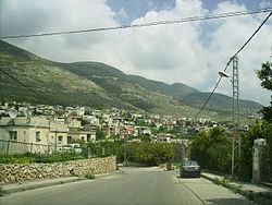
Sajur (Hebrew: סָג'וּר; Arabic: ساجور) is an Druze town (local council) in the Galilee region of northern Israel, with an area of 3,000 dunams (3 km²). It achieved recognition as an independent local council in 1992. In 2015 it had a population of 4,014.
Contents
- Map of Sajur Israel
- History
- Ottoman era
- British Mandate era
- Demographics
- Landmarks
- Notable residents
- References
Map of Sajur, Israel
History
A salvage dig in January 2002 on behalf of the Israel Antiquities Authority excavated a tomb with 13 loculi that dated to the Roman–Byzantine periods, a tomb with eight or nine loculi dating to the end of the second century CE and a small tomb with a single room dating to the first–second centuries CE. The presence of many finds at the bottom of the stratigraphic sequence is evidence of Iron Age occupation at Sajur.
In the Crusader era Sajur was known as Seisor or Saor. In 1249 John Aleman transferred land, including the Casales of Beit Jann, Sajur, Majd al-Krum and Nahf to the Teutonic Knights.
In 1322 Marino Sanuto the Elder showed Sanur on his map, named Seggori.
Ottoman era
In 1875, Victor Guérin noted that "It is today a small village, inhabited by Druze; it is located on a hill that was once completely covered with houses. At the bottom, some gardens are planted with fig, olive, pomegranate and mulberry trees."
In 1881, the Palestine Exploration Fund's Survey of Western Palestine (SWP) described it as: "A village, built of stone, containing about 100 Druzes; in the plain, with olives and arable land; water from cisterns and spring near".
British Mandate era
In the 1922 census of Palestine conducted by the British Mandate authorities, Sajur had a population of 196; 176 Druse, 17 Muslims and 3 Christians, where the Christians were all Orthodox. The population increased in the 1931 census to 254; 141 Druse, 11 Muslims and 2 Christians, in a total of 53 houses.
By 1945, Sajur had 350 inhabitants; 10 Muslims and 340 classified as “others” (=Druse). They owned a total of 8,172 dunams of land, while 64 dunams were public. 4 dunams were used for citrus and bananas, 1,380 for plantations and irrigable land, 1,933 for cereals, while 7 dunams were built-up (urban) land.
Demographics
According to Israel Central Bureau of Statistics, the town had a low ranking (3 out of 10) on the country's socioeconomic index (December 2001). The average salary that year was NIS 3,531 per month, whereas the national average was NIS 6,835.
Landmarks
According to Jewish tradition, the tombs of Ishmael ben Elisha ha-Kohen and Simeon Shezuri are located in Sajur.