
Population (2006) 105 Local time Wednesday 5:25 AM | Canton Noyers Area 14.36 km² | |
 | ||
Region Bourgogne-Franche-Comté Weather 6°C, Wind SW at 5 km/h, 95% Humidity | ||
Sainte-Vertu is a commune in the Yonne department in Bourgogne-Franche-Comté in north-central France.
Contents
Map of 89310 Sainte-Vertu, France
Geography
The surrounding communes are Môlay, Poilly-sur-Serein and Aigremont. Sainte-Vertu is situated 27 km (17 mi) to the south-east of Auxerre which is the nearest large town.
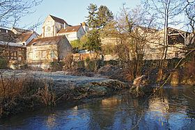
The village is traveresed by the little Serein River. The Morvan natural park is approximately 29 km (18 mi) away.
Local Politics
In 2010 the mayor is Andre Oppendeau.
Demography
Recorded population peaked at 544 in 1821, but has fallen back steadily subsequently, the decline accelerating with the mechanisation of agriculture in the twentieth century. By 2005 the recorded population stood at just 104.
References
Sainte-Vertu Wikipedia(Text) CC BY-SA