
Canton Duclair Area 13.18 km² Local time Wednesday 1:35 AM | Region Normandy Population 2,277 (1999) | |
 | ||
Weather 8°C, Wind SW at 11 km/h, 82% Humidity | ||
Saint-Pierre-de-Varengeville is a commune in the Seine-Maritime department in the Haute-Normandie region in northern France.
Contents
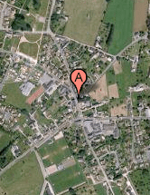
Map of 76480 Saint-Pierre-de-Varengeville, France
Geography
A small town of forestry, farming and a little light industry situated by the banks of the Seine, some 7 miles (11 km) northwest of Rouen at the junction of the D90, D43 and the D86 roads.
Places of interest
References
Saint-Pierre-de-Varengeville Wikipedia(Text) CC BY-SA