
Province / Metropolitan city none Demonym(s) Saint-pierroleins Postal code 11010 | Region Valle d'Aosta Elevation 731 m (2,398 ft) Local time Wednesday 1:20 AM | |
 | ||
Frazioni Bourg (chef-lieu), Alleysin, Babelon, Bachod, Bercher, Bosses, Bressan, Breyes, Bussan Dessous, Bussan Dessus, Bussan du milieu, Caillet, Champrétavy, Chantel, Charrion, Château-Feuillet, Cognein, Combaz, Combellin, Creuzet, Étavel, Grandzettaz, Homené dessous, Homené dessus, Jacquemin, Jeanton, Jonin, La Barmaz, La Charrère, La Croix, La Grange, La Pièce, La Rosiére, Luboz, Méod dessous, Méod dessus, Montagnine, Ordines, Orléans dessous, Orléans dessus, Orléantson, Pelon, Perchut, Plan Châtelair, Pommier, Praulin, Praximond, Preille, Prieuré, Ronchaille, Roserettaz, Rossan, Rumiod de lé, Rumiod dessous, Rumiod dessus, Séez, Tâche, Torrette, Véreytaz, Vergnod, Vermian, Vernes, Verrogne, Vétan dessous, Vétan dessus, Vétan Villette Weather 7°C, Wind W at 6 km/h, 63% Humidity Points of interest Sarriod de la Tour Castle, Château de Saint‑Pierre, Château Feuillet ‑ Azienda, Azienda Vitivinicola Di Barrò | ||
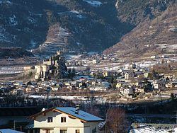
Saint-Pierre is a town and comune in the Aosta Valley region of north-western Italy. There are about 150 medieval castles, tours and fortified houses in the Aosta Valley. The main sight is the Saint-Pierre Castle. Nearby, the Sarriod family built the Sarriod de la Tour Castle.
Contents
Map of 11010 Saint-Pierre, Aosta Valley, Italy
Geography
Saint-Pierre is a town in the Aosta Valley, a bilingual region in the Italian Alps, 110 km (68 mi) north-northwest of Turin. It is situated near the Italian entrance of the Mont Blanc Tunnel, near the confluence of the Buthier and the Doire baltée, and near the junction of the Great and Little St. Bernard routes.
Twin towns — Sister cities
Saint-Pierre is twinned with:
Main sights
References
Saint-Pierre, Aosta Valley Wikipedia(Text) CC BY-SA