
 | ||
Saint Peter Port Harbour is located in Saint Peter Port. It was a natural anchorage used by the Romans which has been changed into an artificial harbour that is now Guernsey's main port for passengers. Loose cargo and liquids/gas are shipped to/from St Sampson's harbour.
Contents
- History
- Freight and Passengers
- Albert Pier
- North or Crown Pier
- St Julians Pier
- Castle Pier
- Fish Quay
- Local yachts
- Visiting yachts
- Cruise ships
- Memorials
- References
Castle Cornet has formed the harbour main defence for centuries. The castle was formerly a tidal island, but since 1859 a breakwater has connected it to the enlarged harbour.
History
The earliest evidence of shipping was the discover of a wreck in 1982 in the entrance of the harbour, which has been named “Asterix”. It is thought to be a 3rd-century Roman cargo vessel and was probably at anchor or grounded when the fire broke out.
The first breakwater, from before the 13th century was a mole, made of loose stones, where the Albert Pier now stands.
The English Civil War saw the harbour in the firing line in 1643 between the Royalist held Castle Cornet and the Parliamentarian held town. Cannonballs fired from the castle caused some damage to the town.
In 1831 gas lamps replaced oil lamps on quays, in 1857 electric lights were demonstrated. The harbour piers were extended by 1864 to allow ships to berth at any state of the tide. Problems were experienced with many piers, quicksand, subsidence and bulges were often solved with piles and by reducing the weight through making problem piers hollow. Dredging in 1899 and removal of some rock from the harbour bed, improved services.
Since 1881 the harbour has housed the Saint Peter Port Lifeboat Station.
The First World War saw the establishment of a French seaplane base, on the pier close to Castle Cornet, in St Peter Port. The pilots flew on constant watch for German submarines.
On 28 June 1940, German commanders sent a squadron of bombers over the islands and bombed the harbours of Guernsey and Jersey. In St Peter Port, the main town of Guernsey, some lorries lined up to load tomatoes for export to England were mistaken by the reconnaissance for troop carriers. Forty-four islanders were killed in the raids. The BBC then broadcast the message that the islands had been declared "open towns" and later in the day reported the German bombing of the island.
The Second World War saw the town also bombed by Allied bombers which killed harbour workers and caused damage to the harbour, such as on 14 June 1944, having been identified by Cryptanalysis of the Enigma intercepts, which was confirmed with a solo photographic reconnaissance Spitfire from No. 541 Squadron RAF, German submarine U-275 was attacked by no less than 8 Hawker Typhoon strike attack aircraft of No. 263 Squadron RAF while tied up in harbour. No damage was caused to the submarine; escorting vessels were not so lucky, where the rockets hit a Dutch coaster M.V. Karel in the harbour. Many windows in town were shattered including most of those in the Town Church.
The Nazi German forces improved the defences of the harbour including building a number of steel and concrete bunkers and casemates, most of which are located on the Castle pier. One bunker was removed from the New Jetty after the war due to fears that weight may collapse the jetty. Considerable work has recently been undertaken strengthening the New Jetty.
During the mid 1980s the harbour was dredged to provide easier access for shipping, with the excavated aggregate pumped through pipes to reclaim the land currently used for the North Beach parking, between the harbour and the Queen Elizabeth II Marina.
Freight and Passengers
A passenger terminal and customs facilities are located on St Julian's Pier.
Facilities at the harbour include two ro-ro ramps for cars and lorries that travel on car/passenger ferries such as the 102m long trimaran Condor Liberation or freight/car/passenger traditional ferries such as the Commodore Clipper.
Two large cranes and a number of smaller ones facilitate the loading/unloading of containers.
Albert Pier
The southern arm of the original harbour going east from near the Town Church was originally a mole, referred to in 1275 by Edward I of England when it was mentioned as needing reconstruction, given permission to raise a local tax to cover the cost, little was done until a dry stone pier, was constructed by 1580. The pier was well built, standing 35 ft high and 360 ft long, paved with a parapet and still being in good condition in 1815. Improved in 1861-63 with north return arm now at right angles. It was renamed in honour of Prince Albert who had died in 1861. A statue of Prince Albert, a copy of an original by Joseph Durham, was erected in 1863.
North or Crown Pier
The northern arm of the original harbour heads east from the Quay, with a retaining pier for the Careening Hard going north. Originally built from 1703 as a breakwater, gradually improved and by 1750 was completed as a dry construction with an arm heading south east.
The harbour quay was completed by the late 1770s, prior to that everything was landed on the beach, cattle still being made to swim ashore.
In 1838 the entrance to the old harbour was widened to make it 40 ft at the top and 68 ft at the bottom. In 1893 the pier was rebuilt to 220 ft length.
St Julians Pier
St Julian's Pier is the pier running east from St Julian's Avenue roundabout. The foundation stone for the pier being laid in 1853. The first weighbridge was built on the pier in 1861, later rebuilt in stone in 1892 and upgraded to 20-ton in 1923. Moving east along the pier you reach the Cambridge Berth (1909), the new Inter-Island Quay, the Ro-Ro ramps (1975), the New Jetty (1927) and finally the White Rock Pier with its Lo-Lo facilities.
Castle Pier
The Castle Pier was constructed in the 1850s to protect the southern side of the expanded harbour. Connecting the south esplanade with Castle Cornet to the east. There is a retaining wall for the Albert Marina, the Fish Quay built from the model yacht pond, a connecting bridge to Castle Cornet, and at the end the Castle Breakwater, authorised in 1854, completed in 1861, with its lighthouse completed 1868. The abattoir was completed and the Victoria Boat Pond, later called the Model Yacht Pond, was opened in 1887 for Queen Victoria’s Diamond Jubilee. In the First World War a French seaplane base was established on the pier, next to the pond.
From 1931 to 1951 oil was imported at the Albert dock, the Germans building tunnels in 1942 to house fuel containers at La Vallette, the tunnels now form a museum.
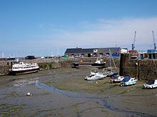
Fish Quay
A purpose built quay built in 1987 with a reinforced concrete deck supported on piles with pontoons, built out from the Castle Pier to provide facilities for the small number of local fishing boats.
Local yachts
Two marinas are dedicated to local yachts and motor boats. The smaller original 1975 Albert Marina, located between the Castle and Albert piers and the newer Queen Elizabeth II Marina located north of the St Julian's Pier which was opened by Her Majesty Queen Elizabeth II in 1989. Both marinas have retaining sills.
Visiting yachts
Visiting tourist yachts and motor vessels can tie up to pontoons inside the inner harbour, which has a fixed barrier to maintain water in the harbour at low tide, or may moor against outer harbour deep water pontoons. St Peter Port marina is the largest marina in the British Isles, it hosts over 10,500 visiting yachts every year.
Cruise ships
The island has become a regular destination for cruise ships with over 100 ships arriving between April and October and is the largest tender port for cruise liners in Europe.
The restricted size of the harbour will not allow cruise ships to enter resulting in the ships needing to anchor in the roads. The disembarkation of passengers, mainly using their own ships tenders was, until 2014 using a ro-ro ramp on the White Rock pier until an alternative pontoon and ramp were installed attached to the Albert Pier. Initially the ramp caused complaints as it was considered too steep to passengers to climb when tides were very low, in 2015 this was rectified with a longer ramp which reduced the gradient.
Businesses are developing for transporting and entertaining the 130,000+ annual visitors, with some queues being experienced on days when two large ships arrive on the same day.
Memorials
A number of commemoration plaques and memorials are located at the harbour: