
Country Canada Founded 1797 Time zone AST (UTC−4) Population 930 (2011) | Incorporated November 9, 1966 Area 200 ha Local time Tuesday 5:45 PM Area code 506 | |
 | ||
Weather -1°C, Wind E at 3 km/h, 82% Humidity | ||
Saint-Louis-de-Kent is a Canadian village in Kent County, New Brunswick.
Contents
Map of Saint-Louis de Kent, NB, Canada
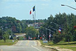
Often shortened to simply Saint-Louis, the village is situated on the Kouchibouguacis River at the main entrance to Kouchibouguac National Park. It is considered as the birthplace of the Acadian Flag. A local park, parc des forgeron, celebrates the birth of this flag in 1884.
History
Saint-Louis-de-Kent was founded by Joseph Babineau in 1797. L'Académie Saint-Louis was founded in 1874 by Father Marcel-François Richard. The Congregation of Notre-Dame of Montréal founded a convent in 1879. The academy became a college in 1876. Additional facilities included a telephone line between Quebec and Halifax. The college was closed in 1882 by Bishop James Rogers.
The Saint-Louis Caisse Populaire was founded in 1938. L'école Monseigneur Marcel-François-Richard was opened in 1978.
Demographics
Population trend