
Intercommunality Pic-Saint-Loup Area 12.73 km² Population 4,581 (1999) | Region Occitanie Canton Matelles Time zone CET (UTC+1) Local time Tuesday 6:24 PM | |
 | ||
Weather 18°C, Wind SW at 16 km/h, 55% Humidity | ||
Saint-Clément-de-Rivière is a municipality located close to Montpellier, in the Hérault department in the Occitanie region in southern France.
Contents
- Map of 34980 Saint ClC3A9ment de RiviC3A8re France
- Geography
- Population
- History
- Politics
- Personalities linked to the city
- Coat of arms
- References
Map of 34980 Saint-Cl%C3%A9ment-de-Rivi%C3%A8re, France
Geography
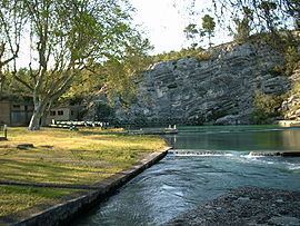
Saint-Clément-de-Rivière is located at about 10 km north from Montpellier. The town has also common limits with several other municipalities: Les Matelles in the north, Prades-le-Lez in the east, Montferrier-sur-Lez in the south-east, Grabels in the south-west and finally Saint-Gély-du-Fesc in the west. The town is 8 km long from north to south, and its total surface is 12.7 km2. The part of the city near Montpellier welcomes a commercial complex called the shopping mall Trifontaine, with a big supermarket and other diversified shops. Saint-Clément-de-Rivière is still covered by a much forest, scrubland and also by crops, even if some areas are now ready to welcome new accommodation buildings and residences. The Saint Sauveur forest has for example seen the construction of the middle and high schools as well as a private hospital. The center of the town called Le Boulidou was designed by François Spoerry, architect of Port Grimaud too. It includes an area where inhabitants can find basic services and goods, such as a bakery, a hairdresser… and also a space with many private houses painted with Mediterranean colors. The river Le Lez has its source on the territory of Saint-Clément-de-Rivière, in the north, in the Saint Sauveur forest, and then continues its way through some villages and crosses the city of Montpellier to finally end in the Mediterranean Sea.
Population
Official population censuses are made since 1793 in the town, and the census made in 2011 states that Saint-Clément-de-Rivière counted 4 926 inhabitants at this period. According to INSEE data, the density of population is 387 inhabitants per km² in 2011. The most represented age bracket is the one counting inhabitants between 60 and 74, which represent 24,9% of the population in 2011, followed by the one with people between 45 and 59 years old, representing 20,5% of the total population. Then about genders, they are rather equally represented in the town with a number of 2 420 men and 2 506 women in 2011. 58% of families in Saint Clément don’t have children under 25 years old, and next the most common number of children is one with 19,2% of families having one child. INSEE leads censuses about Saint-Clément-de-Rivière since 2004. Censuses are made only every five years for municipalities which count less than 10 000 inhabitants, that’s why we don’t have details about the demography after 2011, for now.
History
The first signs of life in Saint-Clément-de-Rivière territory were dated from 2300 before Christ, according to some excavations. The oldest site on the territory is the Cave of Hortus, which seems to come from the Paleolithic era, but not so many signs from the period before -2300 were found. This cave revealed the presence of a sedentary peasant population, living from cereal crops, hunting and breeding. The major part of this cave was unfortunately destroyed during the construction of the road connecting two parts of the town. The name of Saint Clément appeared for the first time en 1109, and has been modified a few times to become Saint-Clément-de-Rivière. It makes a reference to Saint Patron Clément who was one of the first authors of the Church, their texts were found in manuscripts of the New Testament. Saint-Clément-de-Rivière was one of the municipalities supporting the « Republic of Montferrand», established during the 1270s to struggle against the Lord of Montpellier which wanted to tax those small villages. In this Republic of Montferrand, women had the right to vote and the universal suffrage was practiced to elect Mayors and their Councillors. This entity was made of nine parishes : Saint-Clément-de-Rivière, Saint-Gély-du-Fesc, Saint-Mathieu-de-Tréviers, Les Matelles, Saint-Vincent-de-Barbeyrargues, Saint-Jean-de-Cuculles, Valflaunès, Combaillaux and Cazevieille. Nowadays, those municipalities are still united in a community called « Communauté de communes du Pic-Saint-Loup » and counts 17 members in 2014. During the 17th century, the project of building an aqueduct from a source of Saint-Clément-de-Rivière to the center of Montpellier appeared, in order to provide water to the population of the city. Construction according to Henri Pitot’s plans began in 1753 and ended ten years after. The aqueduct was then made longer to begin at the Lez’s source, also on the territory of the town. The aqueduct was used from 1766 until the 1970s.
Politics
From 1989 to 2014, Alphonse Cacciaguera was the mayor of Saint-Clément-de-Rivière, part of the political party RPR which turns into UMP. In 2014, after the municipal elections, a change occurred in the municipality and until 2020 Rodolphe Cayzac is the mayor of the town, part of DVD political party.
Personalities linked to the city
François Spoerry (1912-1999) was a French architect and conceived the « village’s heart » of Saint-Clément-de-Rivière. He is famous in the whole world thanks to the realization of marinas such as Port Grimaud, on the Mediterranean coast of France.
Coat of arms
The coat of arms of Saint-Clément-de-Rivière has, on the left side, a ram, which is the animal meant to have discovered the river’s source with its hoof, according to the legend. On the right side we can see a pine cone to symbolize the vegetation of the town that is mostly covered with forests and scrubland. And in the middle, there is a drawing symbolizing the old bridge across the river which was originally used to bring water to Montpellier, this aqueduct was built following Pitot’s plans.
This coat of arms was created by students of the primary school of Saint-Clément-de-Rivière in November 1983. This was an idea of the Municipal Commission, because the town didn’t have any coat of arms before, to create a distinctive sign for the city. It now appears on official files, on municipal vehicles…