Girish Mahajan (Editor)

Saint Bouize

Updated on
Edit
Like
Comment
Share on FacebookTweet on TwitterShare on LinkedInShare on Reddit
Country
  
France

Department
  
Cher

Time zone
  
CET (UTC+1)

Area
  
14.97 km²

Population
  
295 (1999)

Region
  
Centre-Val de Loire

Canton
  
Sancerre

INSEE/Postal code
  
18200 /18300

Local time
  
Tuesday 5:52 PM

Arrondissement
  
Bourges

Saint-Bouize httpsuploadwikimediaorgwikipediacommonsthu

Weather
  
19°C, Wind W at 14 km/h, 48% Humidity

Saint-Bouize is a commune in the Cher department in central France.

Contents

Map of 18300 Saint-Bouize, France
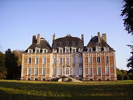
Sights

  • Chateau Lagrange-Montalivet, 1590.
  • Church St. Baudel (twelfth century for its oldest parts): Built in four stages, ... The base is a Romanesque church Berry "pure", consisting of two rectangles built in the twelfth century. In the fourteenth century, a tower is erected by the Count of Sancerre, at the request of parishioners. At the heart of religious wars, the tower is suffering: it was twice as high in the beginning. In the eighteenth century a sacristy was built in 1836 and a chapel. In 1850, the priest asks its demolition for a more modern building, which will be rejected [2].
  • Bridge-channel mold which allows the lateral canal to cross the Loire River Moule, 1893.
  • Geography

    The river Vauvise flows north through the middle of the commune. The Château de Montalivet-Lagrange is here.

    References

    Saint-Bouize Wikipedia