
Country Canada RCM Le Granit Time zone EST (UTC−5) Area 284.1 km² Province Québec | Region Estrie Constituted January 13, 1900 Postal code(s) G0Y 1R0 Population 695 (2011) Area code 819 | |
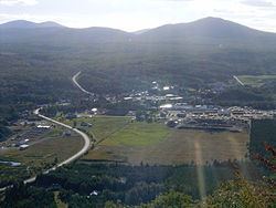 | ||
Saint-Augustin-de-Woburn, known locally as Woburn, is a parish municipality in Le Granit Regional County Municipality in the Estrie region of Quebec, Canada, on the Canada–United States border. The population is 695 as of the Canada 2011 Census.
Contents
Map of Saint-Augustin-de-Woburn, QC, Canada
Overview
Mount Gosford lies entirely within the parish, making Woburn one of the highest towns in Quebec, at an altitude of 1,193 metres (3,914 ft).
The border crossing of Woburn-Coburn Gore is located roughly five kilometres from the town centre, linking Quebec Route 161 with Maine State Route 27. The border crossing offers a 24-hour year-round service.
References
Saint-Augustin-de-Woburn, Quebec Wikipedia(Text) CC BY-SA