
Time zone GMT Local time Tuesday 9:23 AM | Area 4.4 km² | |
 | ||
Weather 10°C, Wind S at 16 km/h, 93% Humidity | ||
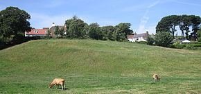
Saint Andrew (Guernésiais: Saint Andri; French: Saint-André-de-la-Pommeraye) is located in the centre of Guernsey and as such is the only parish on the island to be landlocked.
Contents
Map of Saint Andrew, Guernsey
As it is customary to list the parishes round the coast, either clockwise or anti-clockwise, starting with St Peter Port, St Andrew is usually the last parish to be mentioned in such a list. This gave rise to the traditional nickname in Dgèrnésiais of the inhabitants of the parish: les croinchaons (the siftings, what is left behind in the sieve).
General
Saint Andrew is located in the centre of the island and features hills and valleys.
St. Andrews is split into two parts one boarding St Peter Port and one Boarding St Saviour and the Forest. The upper part of the parish where the church and the little chapel is situated is very rural.
The parish is mainly agricultural, Best's quarry now being used for water storage.
St Andrews is the most expensive parish for buying property in Guernsey, closely followed by St Pierre Du Bois and St Saviour.
The postal code for street addresses in this parish begins with GY6.
Politics
St Andrew comprises part of the South East administrative division with St Martin.
In the Guernsey general election, 2016 there was a 3,363 or 73% turnout to elect five Deputies. Those elected (in order of votes received) being Heidi Soulsby, Lindsay De Sausmarez, Peter Roffey, Rob Prow and Victoria Oliver.