Neha Patil (Editor)

Saint Éphrem de Beauce, Quebec

Updated on
Edit
Like
Comment
Share on FacebookTweet on TwitterShare on LinkedInShare on Reddit
Country
  
Canada

RCM
  
Beauce-Sartigan

Time zone
  
EST (UTC−5)

Area
  
119 km²

Local time
  
Tuesday 9:52 PM

Region
  
Chaudière-Appalaches

Constituted
  
24 December 1997

Postal code(s)
  
G0M 1R0

Population
  
2,567 (2011)

Province
  
Québec

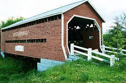
Saint-Éphrem-de-Beauce, Quebec httpsuploadwikimediaorgwikipediacommonsthu

Weather
  
0°C, Wind N at 6 km/h, 100% Humidity

Saint-Éphrem-de-Beauce is a municipality in the Municipalité régionale de comté de Beauce-Sartigan in Quebec, Canada. It is part of the Chaudière-Appalaches region and the population is 2,680 as of 2006. It was named after Ephrem the Syrian.

Contents

Map of Saint-%C3%89phrem-de-Beauce, QC, Canada

Flag origin

It incorporates the same colours as the French flag as a sign of the community's French identity. The three green maple leaves on a white background represent its maple country location, while the number three is for the founding communities of Saint-Isidore, Sainte-Marie and Beauceville. The flag was adopted in 1955.

Economy

Some important industries are there so:

  • René Matériaux Composites
  • Porte Baillargeon
  • Industrie PHL
  • Filature Lemieux
  • Transport Couture
  • Administration

  • 1855 : Constitution of the municipalité de canton de Tring
  • 1866 : The municipalité de paroisse de Saint-Éphrem-de-Tring is created during the breakup of Tring.
  • 1870 :Saint-Éphrem-de-Tring changes its status to municipality.
  • 1897 :The municipalité de village de Saint-Éphrem-de-Tring detaches from the municipality.
  • 1956 :The municipality of Saint-Ephrem de Tring changed its name tomunicipalité de paroisse de Saint-Éphrem-de-Beauce
  • 1997 : Fusion between Saint-Éphrem-de-Tring and Saint-Éphrem-de-Beauce to become the municipalité de Saint-Éphrem-de-Beauce.
  • References

    Saint-Éphrem-de-Beauce, Quebec Wikipedia


    Similar Topics