
Length 225 km | Source Lộc Ninh | |
 | ||
Bridges Phú Mỹ Bridge, Saigon Bridge, Binh Loi New Bridge | ||
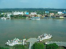
The Saigon River (Vietnamese: Sông Sài Gòn) is a river located in southern Vietnam that rises near Phum Daung in southeastern Cambodia, flows south and south-southeast for about 230 kilometres (140 mi) and empties into the Nhà Bè River, which in its turn empties into the East Sea some 20 kilometres (12 mi) northeast of the Mekong Delta.
Contents
Map of Saigon River
The Saigon River is joined 29 kilometres (18 mi) northeast of Ho Chi Minh City (formerly named Saigon) by the Đồng Nai river, and just above Ho Chi Minh City it is joined by the Ben Cat River. Saigon River is important to Ho Chi Minh City as it is the main water supply as well as the host of Saigon Port, which a total cargo volume load/outloaded of more than 35 million metric tons in 2006.
The Bình Quới Tourist Village is located on the Thanh Da peninsula on the Saigon River, in the Bình Thạnh District of Ho Chi Minh City.
Thủ Thiêm Tunnel, an underwater tunnel passing below the Saigon River, was open to traffic on November 20, 2011. It has been the longest cross-river tunnel in Southeast Asia since its completion.