
Major islands Saibai, Kauamag Width 5.2 km (3.23 mi) Elevation 1.7 m | Adjacent bodies of water Torres Strait Length 21.8 km (13.55 mi) Highest elevation 1.7 m (5.6 ft) Area 107.9 km² Adjacent body of water Torres Strait | |
 | ||
Saibai island history culture dance 1 3
Saibai Island is an island of the Torres Strait Islands archipelago, located in the Torres Strait of Queensland, Australia. The island is situated north of the Australian mainland and south of the island of New Guinea.
Contents
- Saibai island history culture dance 1 3
- Map of Saibai Island Queensland 4875 Australia
- Geography
- Islanders
- History
- Heritage listings
- References
Map of Saibai Island, Queensland 4875, Australia
Most of the island is held under native title, apart from some government infrastructure and historic buildings.
Geography
The island was formed by alluvial deposits from Papua New Guinean rivers.
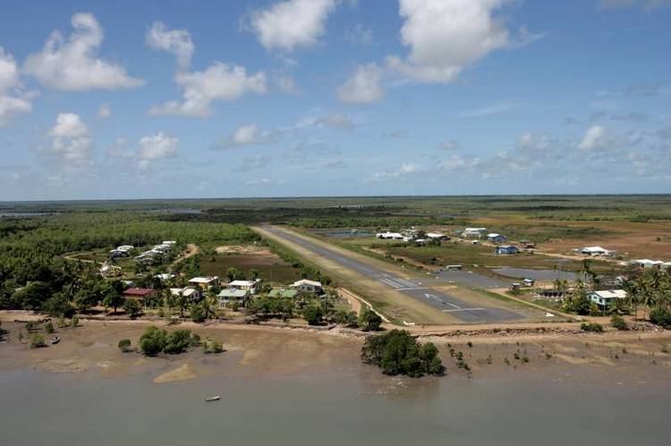
Saibai Island is a fairly large low-lying island located 8 kilometres (5.0 mi) south of the Papua New Guinea mainland. Close to the north of Saibai is the uninhabited Kauamag Island, separated from Saibai by a channel that is 7 kilometres (4.3 mi) long, between 180 and 650 metres (590 and 2,130 ft) wide, and nearly blocked at its east end.
The island is about 21.8 kilometres (13.5 mi) in length by 5.2 kilometres (3.2 mi) in width, and is flat, predominantly mangrove swamplands, with the highest point being 1.7 metres (5 ft 7 in) above mean sea level, and prone to flooding during the wet season, which coincides with king tides. A bitumen airstrip allows year-round access.
The main village of Saibai, in the northwest, has a population of 171. The second village, Churum [Surum White Sand], in the southwest, numbers 128.
Islanders
Only a small proportion of the island is inhabited. The population is transient and was recorded as 337 people at the 2006 census census. The population is 70% indigenous, Torres Strait Islander people, with 25% Papuan and 5% White Australian.
The language spoken on Saibai is Kalaw Kawaw Ya (KKY). Saibai Islanders have always traded and had good relations with neighbouring Papuans. The Saibai Islanders converted to Christianity in 1871 with the arrival of the London Missionary Society.
History
After Saibai Island was devastated by abnormally high tides wave after World War Two, a group of Saibai islanders, led by Bamaga Ginau, accepted Government assistance to resettle on Cape York. The village of Saibai was totally flooded by 10 metres (33 ft) of water. Erosion and a lack of freshwater were concerns. Once a site was chosen inland of Red Island, the new town was named Bamaga. Later some moved to a new settlement at Red Island Point on the coast and named it Seisia.
In January 2012, very high tides inundated the island's cemetery and damaged sacred gravesites.
Heritage listings
Saibai Island has a number of heritage-listed sites, including the Holy Trinity Church.