
Population 11,425 (2005) | Region Caribbean Foundation circa 1607 Local time Monday 6:58 AM | |
 | ||
Website www.sabanasdesanangel-magdalena.gov.co Weather 24°C, Wind SW at 6 km/h, 95% Humidity | ||
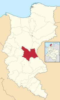
Sabanas de San Ángel ([saˈβanas ðe san ˈaŋxel]), Spanish for Savannas of Saint Angel, is a town and municipality of the Colombian Department of Magdalena. Founded around 1607 with the name San Antoñito by the Spanish Colonizers as a pathway town in the route between La Guajira Department and the Magdalena River. On June 24, 1999 the municipality is created with the name of Sabanas de San Angel that segregated from the municipalities of Ariguaní, Pivijay, Chibolo and Plato.
Contents
Map of Sabanas de San %C3%81ngel, Magdalena, Colombia
Administrative divisions
Corregimientos and caseríos:
References
Sabanas de San Ángel Wikipedia(Text) CC BY-SA