
Country Thailand Capital Sa Kaeo town | Area 7,195 km2 Population 552,187 | |
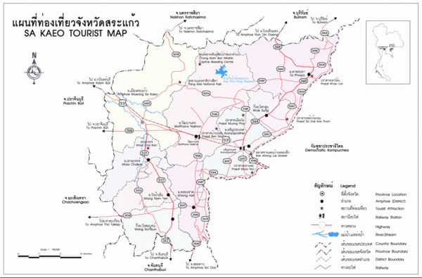
Map of Sa Kaeo Province
Sa Kaeo (Thai: สระแก้ว, [sàʔ kɛ̂ːw]) is a province (changwat) of Thailand. It is in the east of Thailand. Neighboring provinces are (from south clockwise) Chanthaburi, Chachoengsao, Prachinburi, Nakhon Ratchasima, and Buriram. To the east it borders Banteay Meanchey and Battambang of Cambodia.
Contents
- Map of Sa Kaeo Province
- Walk through market aranyaprathet in sa kaeo province phil in bangkok
- History
- Geography
- Symbols
- Administrative divisions
- References
Walk through market aranyaprathet in sa kaeo province phil in bangkok
History
Sa Kaeo became a province in 1993, when the six districts Sa Kaeo, Khlong Hat, Wang Nam Yen, Aranya Prathet, Ta Phraya and Watthana Nakhon of Prachinburi were elevated to provincial status. It is thus one of the four newest provinces of Thailand, together with Amnat Charoen, Nong Bua Lamphu, and most recently, Bueng Kan.
In 1979 Sa Kaeo Refugee Camp was established northwest of Sa Kaeo town.
Geography
The north of the province is covered with the forested mountains of the Sankamphaeng Range and the Dangrek Mountains. To the south are the foothills of the Cardamom Mountains, which are mostly deforested.
Two national parks are found in the province: Pang Sida National Park was established in 1982, Ta Phraya National Park in 1996.
Symbols
The provincial seal shows the sun rising over archaeological ruins, Prasart Kao Noi Si Chom Poo, an important Khmer temple. The rising sun symbolizes the location of the province in the east. In the front is a Buddha image in a pond with lotus flowers.
Provincial tree is Phyllanthus emblica. The provincial flower is the Orange Jessamine (Murraya paniculata).
The provincial slogan is The frontier of the east, beautiful forests and splendid waterfalls, plenty of ancient civilisations, and the commercial venue between Thailand and Cambodia.
Administrative divisions
Sa Kaeo is divided into nine districts (amphoe). The districts are further subdivided into 59 sub-districts (tambon) and 619 villages (muban).