
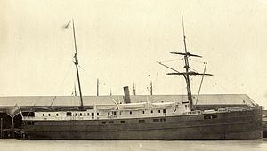
Name SS City of Chester Builder John Roach, New York Launched 1875 Beam 10 m | Owner Oregon Railroad Co. Completed 1875 Length 62 m | |
 | ||
Fate Sunk in collision 22 August 1888 | ||
The SS City of Chester was a steamship built in 1875 that sank after a collision with RMS Oceanic at the Golden Gate in San Francisco Bay on August 22, 1888.
Contents
City of Chester was 202 feet (62 m) long. She was owned by the Oregon Railroad Co. and leased by the Pacific Coast Steamship Company.
Sinking
Headed to Eureka, California, with 90 passengers on the foggy morning of August 22, 1888, at about 10 am she collided with RMS Oceanic, a liner inbound from Hong Kong. The two ships saw each other, but as was later determined by a British Naval Court, City of Chester was caught by tidal current and carried into the path of the larger ship. An eyewitness aboard Oceanic said: "Into her we crashed with irrisistible force, cutting her just as though she was a cheese." She sank in six minutes, and despite rescue efforts by those aboard Oceanic, thirteen passengers, including two children, and three crew members died. In terms of loss of life, this is the second most deadly wreck in the history of San Francisco Bay, after the sinking of the SS City of Rio de Janeiro in 1901.
Oceanic had Chinese crew and her steerage passengers were Chinese immigrants; anti-Chinese xenophobia was high in the US at the time and initially the Chinese were accused of letting City of Chester's passengers drown. When news of their efforts to save them came out, it helped to reduce the prejudice against the Chinese.
Discovery of wreck
The wreck is located in 217 feet (66 m) of water just inside the Golden Gate Bridge at 37°48′50″N 122°28′00″W and was found in May 2013 by NOAA Office of Coast Survey Navigational Response Team 6 using multi-beam sonar. It is only 400 feet (120 m) from where it was located by a precursor of NOAA, the U.S. Coast and Geodetic Survey, in September 1888 in a geodetic survey using a wire dragged from the tug Raymond.
An exhibit on City of Chester is to be created at the Gulf of the Farallones National Marine Sanctuary office at Crissy Field. The office occupies the building erected as a lifesaving station in response to the disaster.