
Elevation 111 m (364 ft) Postal code 37574 | Time zone CET/CEST (UTC+1/+2) Dialling code 05561 | |
 | ||
Sülbeck is one of the oldest villages in the city of Einbeck, district Northeim. The development of the village is connected to the saline springs. These were used to produce brine and salt for some hundred years.
Contents
- Map of SC3BClbeck 37574 Einbeck Germany
- Geography
- History
- History of the saltworks
- Remaining buildings
- Harbour
- Arial cableway
- Electricity and telephone
- Narrow gauge field railway
- Recent history
- Village Council DrberSlbeck
- Coat of Arms of Slbeck
- Buildings
- Culture
- Economy
- Literature
- References
Map of S%C3%BClbeck, 37574 Einbeck, Germany
Geography
Sülbeck lies in southern Lower Saxony between the Harz and Solling Mountains. It is located 1 km west of the river Leine, at the western edge of the Leinegraben in the Leine Uplands. The village is immediately west of the nature reserve that is located in the flood retention basin Salzderhelden.
History
Prehistoric settlements in the vicinity of the salt springs is proven: "From the Sülbecker mountain originate some tools that have been manufactured from Neanderthals resting there". During the development of a new housing area "Am Bohrturm" (At the Derrick) in the 1980s further archaeological investigations were carried out which showed that the settlements date back to about 5000 BC. The first written source is to be found in a deed of the monastery Amelungsborn from the year 1210. The deed talks about the "Salinis" at Siburgehusen. On 26 April 1686 the Elector Ernst August of Hanover Calenberg ordered, that in Sülbeck salt works including a graduation tower were to be built. The history of the salt works is the main difference between Sülbeck and its neighbor farming villages.
History of the saltworks
The Duchy of Brunswick-Lüneburg was seeking possibilities for more income and therefore a proposal was made by the administrative head of the county of Salzderhelden, to which Sülbeck belonged, to build salt works in Sülbeck. The project was driven by Otto Friedrich von Moltke, the last resident of the castle Heldenburg, now ruined. Due to the high salinity of the brine with 9,4 % it was planned to boil the brine directly.
Yet exact calculations showed that the costs for the wood used as fuel would have been prohibitively high. So the project was greatly expanded to include a graduation tower to increase the salinity of the brine to about 20%. This first graduation tower was about 166 m long and stretched south from the current Sülbeck village square, Dorfplatz.
In 1686 the first main brine well was ready plus two smaller wells. To pump the brine out of the soil and supply the graduation tower pumps were needed. The only apparent source of power at the time was water, which was in short supply on site. Thus a canal had to be dug to provide water supply from the river Leine, some kilometers upstream from Sülbeck. Water was tapped off the Leine at Hollenstedt, about 6,5 km upwards and following the rim of the Leine valley around the villages Stöckheim and Drüber. At the edge of the current village square the canal made a 90° bend from south to east and the water flowed back into the river Leine about 1 km downstream. About 100 soldiers dug the canal, called "Salzgraben" (salt canal) by the locals at a total construction time of two years. A large undershot waterwheel, installed on the current village square, drove the pumps. A stylized water wheel is now an integral part of the local coat of arms. Also at the present village square in Sülbeck a brine supply tower was built, from which the brine flew onto the graduation towers. In 1689 the industrial plant started operation. Very soon more buildings were added such as a second graduation tower.
Remaining buildings
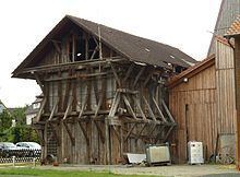
The Upper Drilling Derrick is located in a half timbered building and was restored by a local initiative from 2006 until 2009 and is a Museum since. The Lower Drilling Derrick, directly adjacent to the Brine Reservoir, is still operating and is pumping brine. A small timbered structure was erected over the first brinewell in 1668 which survived until the 1960 and was taken away than to make room for a wider road intersection at Solstraße and Severshuser Weg. It was called "Solhaus" and reconstructed a few meters from the original site in 1992.
The old administrative building, Faktoreihaus, of the than state owned salt works was constructed in 1694. It is located on Solstraße and survives in only slightly altered form. On the right hand side of the building is the chapel used for church services until today (2014). The protruding part of the office building was made so that the officers had a good view of the works area. The building got it´s present form after a rebuild in 1910. There are a few other buildings around Salinenplatz which have been erected in conjunction with the salt works.
Harbour
The transport of the fuel necessary to boil the brine, at first wood, was performed with horse cart. The supply of fuel was the biggest cost element in the operation. Wood was transported from as far as the Harz Mountains. Later the salt works were privatized and used coal as fuel. It had by than access to the newly build railway line which connects Hannover with Kassel, about 3 km away. Consequently, in 1883 the canal was widened east of the present village square in Sülbeck to build a little harbor. The area is build over since 2010. At first the barges were hauled up the canal by horses. In 1886 a small tug was obtained that towed the barges loaded with coal from Salzderhelden to Sülbeck. Two locks were built on the Salzgraben to bridge the height difference between Leine and Salzgraben close to the outflow back into the Leine river. Later the first tug "Theodor" was exchanged against the stronger "Grubenhagen". After an arial cableway had been built the traffic with barges was given up. The rudder of one of the barges is preserved in the museum. The Salzgraben was filled in in the 1970s during the construction of the flood retention basin Salzderhelden.
Arial cableway
During 1908 construction began for an arial cableway to transport coal from the railway station of Salzderhelden to Sülbeck. The cableways starting point was close to the railway station in Salzderhelden. From there it ran through the meadows between Salzderhelden and Sülbeck and reached its end point at the current village square in Sülbeck after crossing the Salzgraben very close to its end point. This cableway remained in service until the Salt works closed operation in 1950 after a bankruptcy. After that many of the buildings were dismantled. The concrete foundations of the cableway can be seen in the meadows as of 2013.
Electricity and telephone
In 1899 a small hydroelectric power station with two turbines was installed in Sülbeck which used the water of the Salzgraben. In the villages Sülbeck and neighbouring Drüber electricity was supplied from December 22, 1899 onwards. Shortly after Vogelbeck on the other side of the river Leine was connected, on Juli 1, 1903 Stöckheim followed. The city of Northeim received electric power only in 1912. In 1894 a telephone line was installed between Hollenstedt and Sülbeck, the first in the area. It was used for communication about the regulation of water supply through the Salzgraben between the two villages.
Narrow gauge field railway
On some of the pictures tracks of a narrow gauge field railway can be seen with a railroad switch on one end. When it was built and later removed is unknown.
Recent history
On 1. March 1974 the village was incorporated into the city of Einbeck.
Village Council Drüber/Sülbeck
Mayor of the village is Rolf Metje (SPD). The current legislative period runs from 1. November 2011 until 31. October 2016.
There is a joint Village Council with Drüber. The by-election on 20. January 2013 due to the incorporation of the former city of Kreiensen into the city of Einbeck brought the following results for the Village Council:
Coat of Arms of Sülbeck
The coat of arms shows the water wheel of the former salt works and the Salzgraben that supplied the water to it.
Buildings
The two Drilling Derricks of the historical salt works built in 1865 and 1882 and the brine reservoir built in 1882 are technical monuments since 1984.
Culture
Since 1989 a local initiative from the south of Lower Saxony organizes a series of concerts, which is known under the name of "Kultur im Esel". Esel (donkey) is the name of a former local pub. It is one of the longest running series of concerts in Lower Saxony. In the series the organizers try to give a stage to relatively unknown artist of different music styles. There are 10 – 15 concerts per annum. During the season 2013 artists as Chris Kavanagh, Sally Barker, Vicki Genfan amongst others, are performing. The non-profit trust "Kultur im Esel" operates an event hall with more performances. There is regularly a "Low German Afternoon", where only the local vernacular, Low German, is spoken.
Sülbeck has many clubs including a sports club, a brass band, a carnival club, and a choir. Heimatverein cares for the Upper Drilling Derrick and was instrumental in preserving it.
Economy
Brine is still produced from a well in Sülbeck.