
Elevation 400 m | Area 22.95 km² | |
 | ||
Súľov-Hradná is a village and municipality in Bytča District in the Žilina Region of northern Slovakia.
Contents
Map of 013 52 S%C3%BA%C4%BEov-Hradn%C3%A1, Slovakia
History
In historical records the village was first mentioned in 1193.
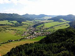
Geography
The municipality lies at an altitude of 400 metres and covers an area of 22.953 km². It has a population of about 929 people.
The village is situated within the Súľov Mountains, and the highest mountain of the picturesque Súľov Rocks, Zibrid (867 m), is part of Súľov-Hradná's territory.
References
Súľov-Hradná Wikipedia(Text) CC BY-SA