
Area rank 327 in Norway Area 207 km² Local time Tuesday 3:17 PM | Demonym(s) Sørumsokning Population 12,768 (2004) Official language form Norwegian Language | |
 | ||
Weather 7°C, Wind S at 24 km/h, 81% Humidity Points of interest Urskog–Høland Line, Blaker Fortress, Bingsfoss stasjon | ||
Sørum is a municipality in Akershus county, Norway. It is part of the traditional region of Romerike. The administrative centre of the municipality is the village of Sørumsand. Sørum was established as a municipality on 1 January 1838 (see formannskapsdistrikt). The municipality of Blaker was merged with Sørum on 1 January 1962.
Contents
Map of S%C3%B8rum, Norway
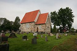
Frogner Old Church
Frogner Old Church (Frogner gamle kirke) dates from ca. 1180. It is part of the Norwegian Church and belongs to Østre Romerike deanery in Diocese of Borg. The edifice is in stone and has 90 seats. The Medieval era church burned in 1918, the walls repaired in 1936, floors and ceilings in 1948. The restoration was completed in 1977.
Name
The municipality (originally the parish) is named after the old Sørum farm (Old Norse: Suđrheimr), since the first church was built here. The first element is suđr which means "southern" and the last element is heimr which means "home/homestead" or "farm".
Coat-of-arms
The coat-of-arms is from modern times. They were granted on 26 June 1981. The arms show a red rose with five petals on a yellow background. The rose is derived from the arms of the medieval dynasty of Sudreim (Sudreimsætten), one of the most influential noble families in Norway at the time. Their name was derived from what is now known as Sørum.
Geography
Sørum is located in the central part of Akershus county. To the north Sørum borders the municipality of Ullensaker, to the east Nes and Aurskog-Høland, in the south Fet, and to the west Skedsmo and Gjerdrum.
Sister cities
The following cities are twinned with Sørum: